IMAGES TAKEN NEAR TO
Haroldswick, Unst, SHETLAND, ZE2 9EQ
Introduction
This page details the photographs taken nearby to ZE2 9EQ by members of the Geograph project.
The Geograph project started in 2005 with the aim of publishing, organising and preserving representative images for every square kilometre of Great Britain, Ireland and the Isle of Man.

There are currently over 7.5m images from over14,400 individuals and you can help contribute to the project by visiting https://www.geograph.org.uk
Image Map
Images are licensed for reuse under creativecommons.org/licenses/by-sa/2.0
Notes
- Clicking on the map will re-center to the selected point.
- The higher the marker number, the further away the image location is from the centre of the postcode.
Image Listing (17 Images Found)
Images are licensed for reuse under creativecommons.org/licenses/by-sa/2.0
Image
Details
Distance
1

Sandfield, Burrafirth
From Upper Sotland, with the flanks of Sothers Field beyond.
Image: © Mike Pennington
Taken: 24 May 2009
0.00 miles
2

Sandfield, Burrafirth
Sothers Field in the background.
Image: © Mike Pennington
Taken: 7 Mar 2014
0.01 miles
3

Moon rising beyond Sandfield, Burrafirth
Image: © Mike Pennington
Taken: 2 Aug 2020
0.01 miles
4

Sandfield, Burrafirth, from the Quoys road
Image: © Mike Pennington
Taken: 13 Nov 2011
0.02 miles

6

Hermaness visitor centre & fields at Burrafirth
The white buildings (middle distance) are the visitor centre. Beyond the end of the bay (Burra Firth), the next land is at the north pole!
Image: © David Wyatt
Taken: Unknown
0.11 miles
7

The road to Burrafirth
The two-storey building was the old Burrafirth school, a side school built as traversing the marshes to the Haroldswick Public School was difficult before the road was built.
Image: © Mike Pennington
Taken: 17 Nov 2012
0.14 miles
8
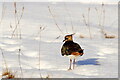
Lapwing (Vanellus vanellus), Burrafirth
Image: © Mike Pennington
Taken: 29 Jan 2021
0.15 miles
9

Burra Firth from near Sandfield
The Cayman Island registered oil supply vessel NS Elina is sheltering from high winds off the Lee of Saxavord.
Image: © Mike Pennington
Taken: 25 Oct 2014
0.16 miles
10

Snow Buntings (Plectrophenax nivalis), Burrafirth
Part of a flock of about 400; Snow Buntings have been very common on Unst this autumn.
Image: © Mike Pennington
Taken: 5 Oct 2013
0.18 miles