IMAGES TAKEN NEAR TO
Braehead Lane, SHETLAND, ZE1 0XT
Introduction
This page details the photographs taken nearby to Braehead Lane, ZE1 0XT by members of the Geograph project.
The Geograph project started in 2005 with the aim of publishing, organising and preserving representative images for every square kilometre of Great Britain, Ireland and the Isle of Man.

There are currently over 7.5m images from over14,400 individuals and you can help contribute to the project by visiting https://www.geograph.org.uk
Image Map
Images are licensed for reuse under creativecommons.org/licenses/by-sa/2.0
Notes
- Clicking on the map will re-center to the selected point.
- The higher the marker number, the further away the image location is from the centre of the postcode.
Image Listing (239 Images Found)
Images are licensed for reuse under creativecommons.org/licenses/by-sa/2.0
Image
Details
Distance
2
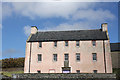
Old Haa, New Street, Scalloway
Category A Listed former laird's house of about 1750, now transformed into three town house apartments for long or short term letting. One of Shetland's finest haa houses. The armorial panel over the doorway commemorates the marriage of James Scott and Katherine Sinclair in 1750. On the buildings at risk register from 1990 it was vacant due to a legal dispute. Conversion to flats was started in 1995 but remained unoccupied and purchased by Scalloway Waterfront Trust in 2001. Restored externally in 2003 it remained unoccupied. Purchased by a private developer around 2006-2008 the interior renovation was completed in 2015.
Image: © Jo and Steve Turner
Taken: 26 Jun 2018
0.02 miles
4
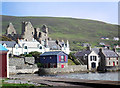
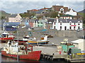
Buildings in Scalloway
The medieval castle in the background, with some Victorian houses in front and what look like modern conversions or rebuilds of dockside buildings by the waterside.
Image: © Des Blenkinsopp
Taken: 15 Jun 2017
0.02 miles
6
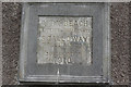
Plaque at Burn Beach
Self-explanatory plaque by the Burn Beach car park.
Image: © Stephen McKay
Taken: 6 Apr 2014
0.03 miles
7
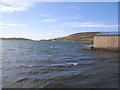
Looking across Blacks Ness, Scalloway
Image: © Nick Mutton 01329 000000
Taken: 24 Aug 2008
0.03 miles
8
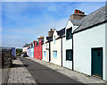
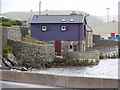
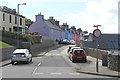
Colourful New Street, Scalloway
A lot of photographs along here. Not surprising, it's very cheerful.
Image: © Des Blenkinsopp
Taken: 15 Jun 2017
0.03 miles
9
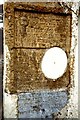
German theories controverted
This curious feature was engraved on the wall of a house in New Street in 1910 by William Johnson, a Scalloway stonemason and amateur scientist:
"This diagram illustrates the cause of the so called Earth Tides. Also each alternate Ocean Flood, the cause of which has never yet been understood. Re Earth Tides: we are told that the Moon raises the solid surface of the Earth under it about 8 inches and raises the OPPOSITE SIDE 8 [inches]. This I hold to be impossible. The phenomenon called EARTH TIDES IS CAUSED BY EARTH's WEIGHT PULLING AGAINST THE SUN'S ATTRACTION.
............
"The water flows back when attraction over & forms a heap on opposite side of Earth. to balance attn. flood. There is no ..." [the rest of the inscription is illegible and appears to have been deliberately effaced.]
The white circle is a diagram of the earth and is also marked:
"GERMAN THEORIES CONTROVERTED
Germans are Not The Favoured of Heaven."
Image: © Tiger
Taken: 29 May 1982
0.03 miles
10
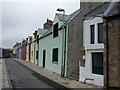
Scalloway: pastel cottages in New Street
An attractive array of colours in these terraced cottages.
Image: © Chris Downer
Taken: 3 Aug 2011
0.03 miles