IMAGES TAKEN NEAR TO
Grodians, SHETLAND, ZE1 0WT
Introduction
This page details the photographs taken nearby to Grodians, ZE1 0WT by members of the Geograph project.
The Geograph project started in 2005 with the aim of publishing, organising and preserving representative images for every square kilometre of Great Britain, Ireland and the Isle of Man.

There are currently over 7.5m images from over14,400 individuals and you can help contribute to the project by visiting https://www.geograph.org.uk
Image Map (Loading...)


Getting Data...Please wait
Leaflet Map data © OpenStreetMap
Images are licensed for reuse under creativecommons.org/licenses/by-sa/2.0
Notes
- Clicking on the map will re-center to the selected point.
- The higher the marker number, the further away the image location is from the centre of the postcode.
Image Listing (11 Images Found)
Images are licensed for reuse under creativecommons.org/licenses/by-sa/2.0
Image
Details
Distance
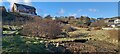
1
Sound, Lerwick, Shetland
This photo was taken in Summer 2005. The edge of the housing development is clear, and can be traced on the 1:25 000 map. Note the upheaval to the top left of the picture - new development, which is no doubt now looking more like a housing estate than a building site.
Image: © Ruth Sharville
Taken: Unknown
0.02 miles
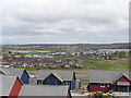
2
Upper Sound
New houses being built on south side of Upper Sound.
Image: © Robbie
Taken: 20 May 2006
0.14 miles
4
Upper Sound
New housing estate being built on the south side of Upper Sound
Image: © Robbie
Taken: 20 May 2006
0.15 miles
5
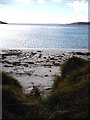
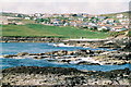
Cable telegraph out to Voe of Sound
Sandy beach at Voe of Sound, with old cable telegraph housing emerging from dunes to begin its long journey south
Image: © Jonathan
Taken: Unknown
0.17 miles
6
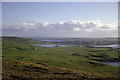
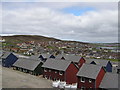
Open moorland to Lerwick from below the Loch of Trebister
This was 1964. The housing developments at Sound and Upper Sound were not even a dream, and Clickimin Broch stood outside the town on the side of Loch of Clickimin. Today a Leisure Centre, retail developments and housing have pushed the limit of Lerwick far into this region (as the images on Geograph and contemporary mapping show). Clickimin Broch is at the centre of this image.
Image: © Julian Paren
Taken: Unknown
0.18 miles
7
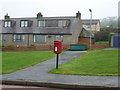
Lerwick: postbox № ZE1 88, Ackrigarth
This small postbox is the most southerly and most westerly of Lerwick's postboxes and serves the Uppersound suburb.
Like all boxes in Lerwick, there are two weekday 'final collection' times, one for off-islands next-day delivery (11:30am) and one for Shetland items (5:15pm). The single advertised Saturday collection is 10:15am.
Image: © Chris Downer
Taken: 2 Aug 2011
0.19 miles
8
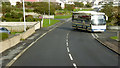
Bus at Uppersound
'Leasks of Lerwick' coach (Y90 JLS) turns into Quoys Road from South Road at Uppersound.
Image: © David Dixon
Taken: 20 Sep 2018
0.19 miles