IMAGES TAKEN NEAR TO
Blydoit Park, SHETLAND, ZE1 0UG
Introduction
This page details the photographs taken nearby to Blydoit Park, ZE1 0UG by members of the Geograph project.
The Geograph project started in 2005 with the aim of publishing, organising and preserving representative images for every square kilometre of Great Britain, Ireland and the Isle of Man.

There are currently over 7.5m images from over14,400 individuals and you can help contribute to the project by visiting https://www.geograph.org.uk
Image Map (Loading...)


Getting Data...Please wait
Leaflet Map data © OpenStreetMap
Images are licensed for reuse under creativecommons.org/licenses/by-sa/2.0
Notes
- Clicking on the map will re-center to the selected point.
- The higher the marker number, the further away the image location is from the centre of the postcode.
Image Listing (22 Images Found)
Images are licensed for reuse under creativecommons.org/licenses/by-sa/2.0
Image
Details
Distance
1
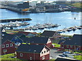
New Housing in Scalloway
Nordic-looking wooden houses above a marina on the east Voe of Scalloway. Blacks Ness with fishing industry warehouses is in the background.
Image: © Colin Smith
Taken: 23 Jul 2010
0.04 miles
2
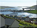
View over the East Voe of Scalloway
New developments at East Voe in the foreground with the castle and the harbour in the middle distance and the Scalloway isles in the distance.
Image: © Mike Pennington
Taken: 25 Oct 2007
0.07 miles
3
View over Blydoit to Scalloway
The silhouette of Scalloway Castle is clear, and to the left of the image can be seen one of the new floating hotels to house gas industry workers in the Isles
Image: © Ruth Sharville
Taken: 2 Jun 2013
0.07 miles
4
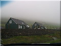
Blydoit from Castle Street, Scalloway, Shetland
Image: © Jo and Steve Turner
Taken: 18 Jun 2018
0.07 miles
5

House with a View
The viewpoint on Scord Hill above Scalloway was specially built to cater for the many cars and buses who stop here to take in the prospect over the East Voe of Scalloway and Cliff Sound.
Image: © Colin Smith
Taken: 23 Jul 2010
0.08 miles
6
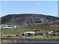
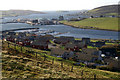
View of Scord Quarry, Scalloway
Looking across the Voe. The development in the foreground is Undir Houl.
The quarry lies in Image and Image
Image: © Robbie
Taken: 9 Aug 2007
0.09 miles
7
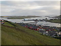
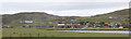
Scalloway: wider view over town and harbour
A wider view similar to Image, taking in the road bridge across to the island of Trondra.
Image: © Chris Downer
Taken: 9 Jul 2013
0.09 miles
8
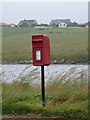
Scalloway: postbox № ZE2 97, Blythoit
This small postbox serves the outer part of Scalloway which is separated from the rest of the town by the East Voe of Scalloway, which is behind the box. The name Blythoit is spelt Blydoit on the Royal Mail's list of boxes.
The box is emptied at 10am each day except Sunday.
Image: © Chris Downer
Taken: 3 Aug 2011
0.10 miles
9
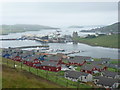
Scalloway: view over the town
Looking across the water towards the town of Scalloway and beyond. In the foreground is the settlement of Blydoit (shown as Blythoit on some maps).
Image: © Chris Downer
Taken: 3 Aug 2011
0.10 miles
10
New house building site at Scalloway
Image: © Bill Griffiths
Taken: 2 Jun 2006
0.10 miles