IMAGES TAKEN NEAR TO
Craigpark Road, SHETLAND, ZE1 0TT
Introduction
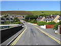
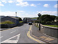
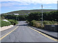
This page details the photographs taken nearby to Craigpark Road, ZE1 0TT by members of the Geograph project.
The Geograph project started in 2005 with the aim of publishing, organising and preserving representative images for every square kilometre of Great Britain, Ireland and the Isle of Man.

There are currently over 7.5m images from over14,400 individuals and you can help contribute to the project by visiting https://www.geograph.org.uk
Image Map (Loading...)


Getting Data...Please wait
Leaflet Map data © OpenStreetMap
Images are licensed for reuse under creativecommons.org/licenses/by-sa/2.0
Notes
- Clicking on the map will re-center to the selected point.
- The higher the marker number, the further away the image location is from the centre of the postcode.
Image Listing (140 Images Found)
Images are licensed for reuse under creativecommons.org/licenses/by-sa/2.0
Image
Details
Distance
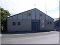
3
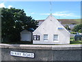
Scalloway Police Station, Berry Road
Image: © Nick Mutton 01329 000000
Taken: 24 Aug 2008
0.06 miles
4
Lovers Lane looking down to New Road
Image: © Nick Mutton 01329 000000
Taken: 24 Aug 2008
0.06 miles
5
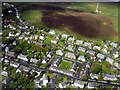
Scalloway aerial view
Seen from a plane on route from Lerwick to Fair Isle.
Image: © John Lucas
Taken: 28 May 2015
0.07 miles
6
Royal British Legion Scotland, Scalloway Branch
Image: © Nick Mutton 01329 000000
Taken: 24 Aug 2008
0.07 miles
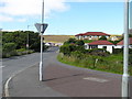
9
Junction of Gibblestone Road, Scalloway
Image: © Nick Mutton 01329 000000
Taken: 24 Aug 2008
0.09 miles
10
Scalloway Town Hall - stained glass window
Image: © Nick Mutton 01329 000000
Taken: 24 Aug 2008
0.09 miles