IMAGES TAKEN NEAR TO
Kantersted Road, SHETLAND, ZE1 0RJ
Introduction
This page details the photographs taken nearby to Kantersted Road, ZE1 0RJ by members of the Geograph project.
The Geograph project started in 2005 with the aim of publishing, organising and preserving representative images for every square kilometre of Great Britain, Ireland and the Isle of Man.

There are currently over 7.5m images from over14,400 individuals and you can help contribute to the project by visiting https://www.geograph.org.uk
Image Map
Images are licensed for reuse under creativecommons.org/licenses/by-sa/2.0
Notes
- Clicking on the map will re-center to the selected point.
- The higher the marker number, the further away the image location is from the centre of the postcode.
Image Listing (97 Images Found)
Images are licensed for reuse under creativecommons.org/licenses/by-sa/2.0
Image
Details
Distance
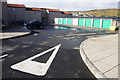
2
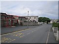
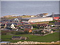
Sandveien, Lerwick
Housing estate on the edge of Lerwick.
Image: © Mike Pennington
Taken: 28 Sep 2012
0.03 miles
4
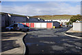
Sandveien, Lerwick
Sandveien is a large (by Shetland standards) housing estate on the edge of Lerwick.
Image: © Mike Pennington
Taken: 28 Sep 2012
0.04 miles
5
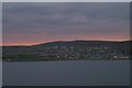
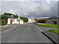
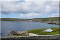
Sound, Lerwick, at dusk
From the Knab.
Image: © Mike Pennington
Taken: 2 Oct 2007
0.04 miles
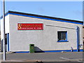
7
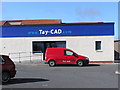
Eric Gray Centre, Kantersted Road, Lerwick
Care centre, with curiously trendy typeface for its logo.
Image: © Mike Pennington
Taken: 28 Sep 2012
0.06 miles
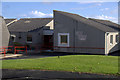
9
Somerfield Supermarket, as seen from Staney Hill
It's a Tesco now, pity buildings have to change hands ;)
Image: © Robbie
Taken: 9 Aug 2007
0.10 miles