IMAGES TAKEN NEAR TO
Burgess Street, SHETLAND, ZE1 0PN
Introduction
This page details the photographs taken nearby to Burgess Street, ZE1 0PN by members of the Geograph project.
The Geograph project started in 2005 with the aim of publishing, organising and preserving representative images for every square kilometre of Great Britain, Ireland and the Isle of Man.

There are currently over 7.5m images from over14,400 individuals and you can help contribute to the project by visiting https://www.geograph.org.uk
Image Map (Loading...)


Getting Data...Please wait
Leaflet Map data © OpenStreetMap
Images are licensed for reuse under creativecommons.org/licenses/by-sa/2.0
Notes
- Clicking on the map will re-center to the selected point.
- The higher the marker number, the further away the image location is from the centre of the postcode.
Image Listing (81 Images Found)
Images are licensed for reuse under creativecommons.org/licenses/by-sa/2.0
Image
Details
Distance
1
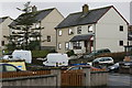
Bruce Crescent, Lerwick
I assume the style of these houses is deliberately intended to reflect the style of many of the old harbourside buildings in Lerwick.
Image: © Mike Pennington
Taken: 20 Mar 2010
0.04 miles
2
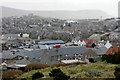
Lerwick rooftops from North Staney Hill
The grey roofs in the foreground belong to houses called the Vadill, which are named after a Vadill (shallow wading place) which was formerly on the site, before land was reclaimed.
Image: © Mike Pennington
Taken: 16 Apr 2011
0.05 miles
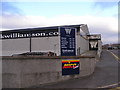
4
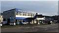
Grantfield Garage, North Road, Lerwick
Image: © Mike Pennington
Taken: 8 Nov 2017
0.09 miles
5
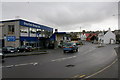
Grantfield Garage, Lerwick
Also in the photo is the first roundabout to be built in Shetland. When it was built in the 1990s there were several weeks of adverts in the local newspaper telling people how to use it.
Image: © Mike Pennington
Taken: 20 Mar 2010
0.09 miles
6
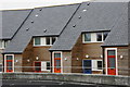
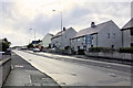
Da Vadill, North Road, Lerwick
Newly-built housing, with brightly-coloured doors. A vadill is a place where a houb or voehead can be crossed by wading at low tide, and the name was chosen by Damien Ristori of Lerwick Community Council to remember the Vadill that was formerly at this site, before the Lerwick docks and quays extended further out into Bressay Sound. A view of the former Vadill can be seen here http://photos.shetland-museum.org.uk/image.php?i=38376&r=2&t=4&x=1
Image: © Mike Pennington
Taken: 20 Mar 2010
0.09 miles
7
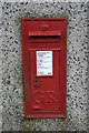
Postbox, North Road, Lerwick
Built into a retaining wall below a house.
Image: © Mike Pennington
Taken: 20 Mar 2010
0.09 miles
8
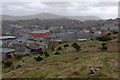
Lerwick from North Staney Hill
Skipidock is just visible on the left, with the bright red of the Toll Clock Shopping Centre just left of centre. The coastguard building on the Knab is on the horizon on the far right. Bressay is in the background. For a similar view from early in the 20th century see http://photos.shetland-museum.org.uk/image.php?i=35686&r=2&t=4&x=1.
Image: © Mike Pennington
Taken: 16 Apr 2011
0.09 miles
10
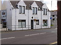
Complementary Health Clinic, North Road, Lerwick
Image: © Robbie
Taken: 8 Aug 2007
0.10 miles