IMAGES TAKEN NEAR TO
Punds, SHETLAND, ZE1 0LP
Introduction
This page details the photographs taken nearby to Punds, ZE1 0LP by members of the Geograph project.
The Geograph project started in 2005 with the aim of publishing, organising and preserving representative images for every square kilometre of Great Britain, Ireland and the Isle of Man.

There are currently over 7.5m images from over14,400 individuals and you can help contribute to the project by visiting https://www.geograph.org.uk
Image Map
Images are licensed for reuse under creativecommons.org/licenses/by-sa/2.0
Notes
- Clicking on the map will re-center to the selected point.
- The higher the marker number, the further away the image location is from the centre of the postcode.
Image Listing (6 Images Found)
Images are licensed for reuse under creativecommons.org/licenses/by-sa/2.0
Image
Details
Distance
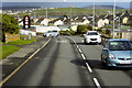
1
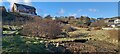
Uppersound, Lerwick
Urban sprawl is everywhere, even in Shetland.
Image: © Mike Pennington
Taken: 25 Oct 2007
0.06 miles
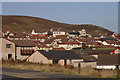
2
Bus at Uppersound
'Leasks of Lerwick' coach (Y90 JLS) turns into Quoys Road from South Road at Uppersound.
Image: © David Dixon
Taken: 20 Sep 2018
0.13 miles
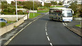
3
Lerwick: postbox № ZE1 88, Ackrigarth
This small postbox is the most southerly and most westerly of Lerwick's postboxes and serves the Uppersound suburb.
Like all boxes in Lerwick, there are two weekday 'final collection' times, one for off-islands next-day delivery (11:30am) and one for Shetland items (5:15pm). The single advertised Saturday collection is 10:15am.
Image: © Chris Downer
Taken: 2 Aug 2011
0.14 miles
4
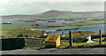
Sound
Sound Brae looking out over the Ness of Sound to Bressay with "Klondyker" Eastern European factory ships.
Image: © Jeremy Duncan
Taken: 27 Jun 1992
0.15 miles
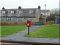
5
Uppersound, South Road
On the southern outskirts of Lerwick.
Image: © David Dixon
Taken: 20 Sep 2018
0.16 miles