IMAGES TAKEN NEAR TO
Fox Lane, SHETLAND, ZE1 0EZ
Introduction
This page details the photographs taken nearby to Fox Lane, ZE1 0EZ by members of the Geograph project.
The Geograph project started in 2005 with the aim of publishing, organising and preserving representative images for every square kilometre of Great Britain, Ireland and the Isle of Man.

There are currently over 7.5m images from over14,400 individuals and you can help contribute to the project by visiting https://www.geograph.org.uk
Image Map
Images are licensed for reuse under creativecommons.org/licenses/by-sa/2.0
Notes
- Clicking on the map will re-center to the selected point.
- The higher the marker number, the further away the image location is from the centre of the postcode.
Image Listing (945 Images Found)
Images are licensed for reuse under creativecommons.org/licenses/by-sa/2.0
Image
Details
Distance
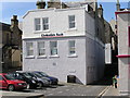
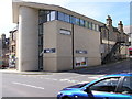
2
Empty shop, Commercial Street, Lerwick
For a long time this was a jewellery shop, although most recently it was a tailor's. It is now vacant.
Image: © Mike Pennington
Taken: 30 Jun 2012
0.00 miles
3
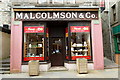
Aa Fired Up, Commercial Street, Lerwick
Ceramics for all - but housed in the former Malcolmson & Co. bakery shop.
Image: © Mike Pennington
Taken: 29 Apr 2017
0.00 miles
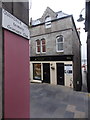
4
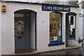
Clive's Record Shop, Lerwick
Principal source of CDs, DVDs and computer games for Lerwegians and it has survived since the mid-1980s at least, when it sold vinyl and cassettes in smaller store near the Queen's Hotel.
Image: © Mike Pennington
Taken: 23 Oct 2008
0.01 miles
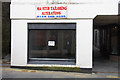
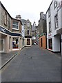
6
Lerwick: Quendale Lane emerges onto Commercial Street
Looking across to 96a Commercial Street (the town's main street) from the bottom of Quendale Lane, one of numerous narrow paths which come steeply downhill in the same way.
The harbour can be glimpsed along the continuing path ahead of us.
Image: © Chris Downer
Taken: 12 Jul 2013
0.01 miles
7

Boots, Lerwick
There are very few national chains in Lerwick, and nearly all the shops on Commercial Street are independent locally-run businesses, but this building has a different history: it was a Templeton supermarket, then it was taken over by Presto before they moved to an 'out-of-town' site (which is now a Tesco - see Image), and now, as can be seen, it belongs to the Boots chain.
Image: © Mike Pennington
Taken: 23 Oct 2008
0.01 miles
8
Commercial Street, Lerwick
Much of Lerwick town centre has been pedestrianised.
Image: © Oliver Dixon
Taken: 21 May 2013
0.01 miles
9
Burns Lane, Lerwick (1)
Burns Lane is not quite opposite Burns Walk and looking at even the most detailed maps on this site is not shown as a lane as it starts off under a building as can be seen here. After a few yards it opens out however - see Image]
Image: © Rob Farrow
Taken: 1 Sep 2011
0.01 miles
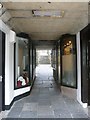
10
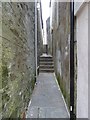
Pilot Lane, Lerwick
Pilot Lane is a very narrow alley running westwards between Burns Lane and Fox Lane.
Image: © Rob Farrow
Taken: 1 Sep 2011
0.01 miles