IMAGES TAKEN NEAR TO
St. Olaf Street, SHETLAND, ZE1 0DA
Introduction
This page details the photographs taken nearby to St. Olaf Street, ZE1 0DA by members of the Geograph project.
The Geograph project started in 2005 with the aim of publishing, organising and preserving representative images for every square kilometre of Great Britain, Ireland and the Isle of Man.

There are currently over 7.5m images from over14,400 individuals and you can help contribute to the project by visiting https://www.geograph.org.uk
Image Map (Loading...)


Getting Data...Please wait
Leaflet Map data © OpenStreetMap
Images are licensed for reuse under creativecommons.org/licenses/by-sa/2.0
Notes
- Clicking on the map will re-center to the selected point.
- The higher the marker number, the further away the image location is from the centre of the postcode.
Image Listing (648 Images Found)
Images are licensed for reuse under creativecommons.org/licenses/by-sa/2.0
Image
Details
Distance
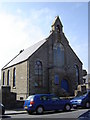
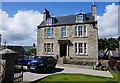
1
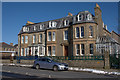
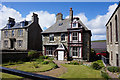
Solheim and Carradale, Lerwick
Former Victorian mansion houses, now B&B establishments.
Image: © Mike Pennington
Taken: 3 Mar 2010
0.02 miles
4
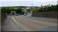
Scalloway Road, Lerwick
The large square building in the distance is the Gilbert Bain Hospital.
Image: © Gordon Brown
Taken: 4 Jun 2018
0.03 miles
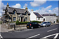
8
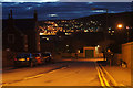
Scalloway Road, Lerwick
From the Hillhead end looking towards the lights of Sound.
Image: © Mike Pennington
Taken: 24 Feb 2013
0.04 miles