IMAGES TAKEN NEAR TO
YO8 9UP
Introduction
This page details the photographs taken nearby to YO8 9UP by members of the Geograph project.
The Geograph project started in 2005 with the aim of publishing, organising and preserving representative images for every square kilometre of Great Britain, Ireland and the Isle of Man.

There are currently over 7.5m images from over14,400 individuals and you can help contribute to the project by visiting https://www.geograph.org.uk
Image Map
Images are licensed for reuse under creativecommons.org/licenses/by-sa/2.0
Notes
- Clicking on the map will re-center to the selected point.
- The higher the marker number, the further away the image location is from the centre of the postcode.
Image Listing (12 Images Found)
Images are licensed for reuse under creativecommons.org/licenses/by-sa/2.0
Image
Details
Distance
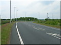
1
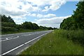
A63 westbound
Looking along the A63 from Field Lane crossing.
Image: © DS Pugh
Taken: 13 Jun 2021
0.05 miles
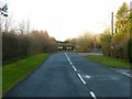
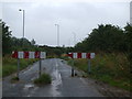
2
End of Field Lane
The A63 is ahead. Cyclists and pedestrians can cross over the road.
Image: © DS Pugh
Taken: 13 Jun 2021
0.07 miles
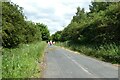
3
Field Lane, Thorpe Willoughby
Originally the road from Brayton to Hambleton, cut when the A63 Selby bypass was built.
Image: © Alan Murray-Rust
Taken: 9 Dec 2019
0.07 miles
4
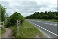
A63 eastbound
Looking along the A63 from Field Lane crossing.
Image: © DS Pugh
Taken: 13 Jun 2021
0.08 miles
6
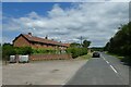
Houses on Field Lane
Looking towards some properties on the outskirts of Thorpe Willoughby.
Image: © DS Pugh
Taken: 13 Jun 2021
0.08 miles
8
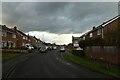
Dane Avenue
Looking along Dane Avenue in Thorpe Willoughby.
Image: © DS Pugh
Taken: 18 Mar 2023
0.18 miles
10
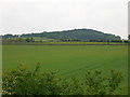
A New Wood
Only a few years old, this wood is on former farmland.
Image: © Timothy Baldwin
Taken: 20 Jul 2005
0.20 miles