IMAGES TAKEN NEAR TO
Linden Way, SELBY, YO8 9ND
Introduction
This page details the photographs taken nearby to Linden Way, YO8 9ND by members of the Geograph project.
The Geograph project started in 2005 with the aim of publishing, organising and preserving representative images for every square kilometre of Great Britain, Ireland and the Isle of Man.

There are currently over 7.5m images from over14,400 individuals and you can help contribute to the project by visiting https://www.geograph.org.uk
Image Map
Images are licensed for reuse under creativecommons.org/licenses/by-sa/2.0
Notes
- Clicking on the map will re-center to the selected point.
- The higher the marker number, the further away the image location is from the centre of the postcode.
Image Listing (55 Images Found)
Images are licensed for reuse under creativecommons.org/licenses/by-sa/2.0
Image
Details
Distance
2
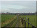
Bridleway near Thorpe Willoughby
Looking north. This track runs parallel to the main village road. The land is partly used for arable crops and partly for horse paddocks.
Image: © Alan Murray-Rust
Taken: 25 Dec 2007
0.06 miles
7

A1238 junction with Dam Lane
Looking along Leeds Road in Thorpe Willoughby.
Image: © DS Pugh
Taken: 13 Jun 2021
0.12 miles
10

Fox Lane resurfaced
Looking along a recently resurfaced Fox Lane before markings have been added.
Image: © DS Pugh
Taken: 13 Jun 2021
0.14 miles