IMAGES TAKEN NEAR TO
Mill Lane, SELBY, YO8 9LB
Introduction
This page details the photographs taken nearby to Mill Lane, YO8 9LB by members of the Geograph project.
The Geograph project started in 2005 with the aim of publishing, organising and preserving representative images for every square kilometre of Great Britain, Ireland and the Isle of Man.

There are currently over 7.5m images from over14,400 individuals and you can help contribute to the project by visiting https://www.geograph.org.uk
Image Map
Images are licensed for reuse under creativecommons.org/licenses/by-sa/2.0
Notes
- Clicking on the map will re-center to the selected point.
- The higher the marker number, the further away the image location is from the centre of the postcode.
Image Listing (12 Images Found)
Images are licensed for reuse under creativecommons.org/licenses/by-sa/2.0
Image
Details
Distance
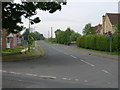
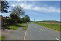
1
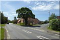
Mill Lane
Looking along Mill Lane in Brayton.
Image: © DS Pugh
Taken: 13 May 2018
0.04 miles
2
Mill Lane from Mill Croft
Looking along Mill Lane in Brayton near the junction with Mill Croft.
Image: © DS Pugh
Taken: 13 May 2018
0.05 miles
3
Mill Lane towards Brayton
Looking along Mill Lane which heads into Brayton from the west.
Image: © DS Pugh
Taken: 24 Feb 2024
0.10 miles
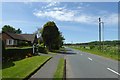
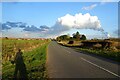
4
Mill Lane, Brayton
The wooded area to the right in the distance is Brayton Barff
Image: © John Slater
Taken: 25 Jun 2017
0.12 miles
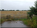
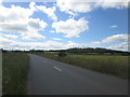
5
Field north of Mill Lane
Mill Lane heads west from Brayton towards the A63 Selby bypass.
Image: © DS Pugh
Taken: 24 Feb 2024
0.12 miles
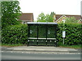
6
Doncaster Road meets Mill Lane
Looking along Doncaster Road (A19) with Mill Lane running off to the right.
Image: © DS Pugh
Taken: 13 May 2018
0.17 miles
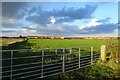
7
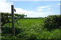
Footpath to the A63
Leading from Mill Lane.
Image: © DS Pugh
Taken: 13 May 2018
0.19 miles