IMAGES TAKEN NEAR TO
Chancery Court, SELBY, YO8 9FA
Introduction
This page details the photographs taken nearby to Chancery Court, YO8 9FA by members of the Geograph project.
The Geograph project started in 2005 with the aim of publishing, organising and preserving representative images for every square kilometre of Great Britain, Ireland and the Isle of Man.

There are currently over 7.5m images from over14,400 individuals and you can help contribute to the project by visiting https://www.geograph.org.uk
Image Map
Images are licensed for reuse under creativecommons.org/licenses/by-sa/2.0
Notes
- Clicking on the map will re-center to the selected point.
- The higher the marker number, the further away the image location is from the centre of the postcode.
Image Listing (44 Images Found)
Images are licensed for reuse under creativecommons.org/licenses/by-sa/2.0
Image
Details
Distance
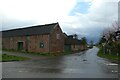
1

Hillam Road, Gateforth
Looking west.
Image: © Alan Murray-Rust
Taken: 9 Dec 2019
0.05 miles
2
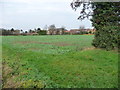
Arable field on the southern edge of Gateforth
The houses are just east of West End Farm.
Image: © Christine Johnstone
Taken: 12 Dec 2018
0.06 miles
3
Edge of Gateforth
Looking along Hillam Road.
Image: © DS Pugh
Taken: 13 May 2018
0.07 miles
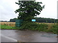
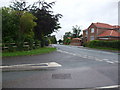
4
Pale Lane
Looking along Pale Lane from Hillam Road in Gateforth.
Image: © DS Pugh
Taken: 18 Mar 2023
0.07 miles

8

Drain on the south side of Gateforth
On the edge of a large expanse of flat land, north of the River Aire.
Image: © Christine Johnstone
Taken: 12 Dec 2018
0.08 miles
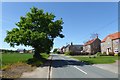
9
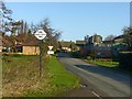
Welcome to Gateforth
Village entrance sign on Pale Lane.
Image: © Alan Murray-Rust
Taken: 9 Dec 2019
0.08 miles
10
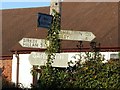
Fingerpost, Gateforth
Still with old-style fingers.
Image: © Alan Murray-Rust
Taken: 9 Dec 2019
0.08 miles