IMAGES TAKEN NEAR TO
Westbourne Road, SELBY, YO8 9DA
Introduction
This page details the photographs taken nearby to Westbourne Road, YO8 9DA by members of the Geograph project.
The Geograph project started in 2005 with the aim of publishing, organising and preserving representative images for every square kilometre of Great Britain, Ireland and the Isle of Man.

There are currently over 7.5m images from over14,400 individuals and you can help contribute to the project by visiting https://www.geograph.org.uk
Image Map
Images are licensed for reuse under creativecommons.org/licenses/by-sa/2.0
Notes
- Clicking on the map will re-center to the selected point.
- The higher the marker number, the further away the image location is from the centre of the postcode.
Image Listing (8 Images Found)
Images are licensed for reuse under creativecommons.org/licenses/by-sa/2.0
Image
Details
Distance
1
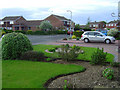
Sandy Rise
Just one of the many streets on the urban fringes of Selby.
Image: © Scott Robinson
Taken: 19 May 2006
0.14 miles
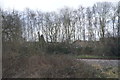
2
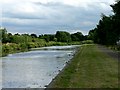
Fishing Platforms on the Selby Canal
Although a broad canal at this point, the design of some bridges would restrict the beam of vessels able to use it
Image: © Roger Gilbertson
Taken: 9 Jul 2006
0.19 miles
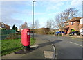
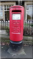
3

Elizabeth II postbox on Westbourne Road, Selby
Image: © JThomas
Taken: 1 Feb 2020
0.21 miles
4
Parkways, Selby
Showing position of Postbox No. YO8 52.
See Image] for postbox.
Image: © JThomas
Taken: 1 Feb 2020
0.22 miles
5
Houses on Westbourne Road, Selby
Showing position of Postbox No. YO8 52.
See Image] for postbox.
Image: © JThomas
Taken: 1 Feb 2020
0.22 miles
6
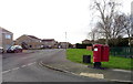
Westbourne Road, Selby
Showing position of Postbox No. YO8 52.
See Image] for postbox.
Image: © JThomas
Taken: 1 Feb 2020
0.23 miles
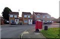
8
Elizabeth II postbox on Doncaster Road, Selby
Image: © JThomas
Taken: 1 Feb 2020
0.25 miles