IMAGES TAKEN NEAR TO
Hagg Bush Lane, YO8 8PB
Introduction
This page details the photographs taken nearby to Hagg Bush Lane, YO8 8PB by members of the Geograph project.
The Geograph project started in 2005 with the aim of publishing, organising and preserving representative images for every square kilometre of Great Britain, Ireland and the Isle of Man.

There are currently over 7.5m images from over14,400 individuals and you can help contribute to the project by visiting https://www.geograph.org.uk
Image Map
Images are licensed for reuse under creativecommons.org/licenses/by-sa/2.0
Notes
- Clicking on the map will re-center to the selected point.
- The higher the marker number, the further away the image location is from the centre of the postcode.
Image Listing (16 Images Found)
Images are licensed for reuse under creativecommons.org/licenses/by-sa/2.0
Image
Details
Distance


3
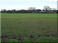
Trees on a field boundary, west of Brickyard Farm
On the north side of Common Lane.
Image: © Christine Johnstone
Taken: 13 Jan 2016
0.09 miles
4

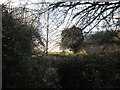
Pool beside Hagg Bush Lane
Looking across a pool to the north of the road near the junction with Selby Road.
Image: © DS Pugh
Taken: 27 May 2023
0.10 miles

6
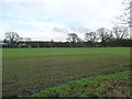
Emerging crop, south-west of Brickyard Farm
On the north side of Common Lane.
Image: © Christine Johnstone
Taken: 13 Jan 2016
0.13 miles
7
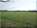
Farmland west of Brickyard Farm
The distant hedge is the boundary between Camblesforth and Barlow parishes.
Image: © Christine Johnstone
Taken: 13 Jan 2016
0.14 miles
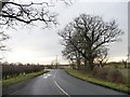
8

Hagg Bush Lane approaching Selby Road
Looking towards the junction with the A1041.
Image: © DS Pugh
Taken: 27 May 2023
0.14 miles
9
Trees along Common Lane
The road is heading east [locally south] to the A1041.
Image: © Christine Johnstone
Taken: 13 Jan 2016
0.15 miles
10
Footpath down from dismantled railway to A1041
The road can just be seen through the undergrowth as the overgrown footpath goes left. The two sets of railings high up left and right are to hopefully stop wild animals falling onto the road below as the bridge has been dismantled
Image: © Martin Dawes
Taken: 11 Dec 2019
0.16 miles