IMAGES TAKEN NEAR TO
Burn Hall Crescent, SELBY, YO8 8LT
Introduction
This page details the photographs taken nearby to Burn Hall Crescent, YO8 8LT by members of the Geograph project.
The Geograph project started in 2005 with the aim of publishing, organising and preserving representative images for every square kilometre of Great Britain, Ireland and the Isle of Man.

There are currently over 7.5m images from over14,400 individuals and you can help contribute to the project by visiting https://www.geograph.org.uk
Image Map
Images are licensed for reuse under creativecommons.org/licenses/by-sa/2.0
Notes
- Clicking on the map will re-center to the selected point.
- The higher the marker number, the further away the image location is from the centre of the postcode.
Image Listing (13 Images Found)
Images are licensed for reuse under creativecommons.org/licenses/by-sa/2.0
Image
Details
Distance
1
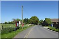
West Lane, Burn
Looking along West Lane. On the left is the parish noticeboard.
Image: © DS Pugh
Taken: 6 May 2018
0.09 miles
2
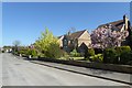
Entering Burn
Coming into Burn along West Lane.
Image: © DS Pugh
Taken: 6 May 2018
0.09 miles
5

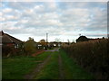
Ruined building, Burn
This was clearly something to do with the nearby RAF airfield, although quite some distance from it.
Image: © Alan Murray-Rust
Taken: 10 Dec 2018
0.14 miles


9

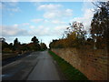
A19 at Burn
Monday morning not one car in sight – the result of the closure of Haddlesey Bridge.
Image: © Alan Murray-Rust
Taken: 10 Dec 2018
0.20 miles
10
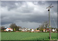
Burn
Looking north-northwest towards Burn village from Brick Kiln Lane.
Image: © Paul Glazzard
Taken: 5 Apr 2008
0.22 miles