IMAGES TAKEN NEAR TO
Doncaster Road, SELBY, YO8 8LA
Introduction
This page details the photographs taken nearby to Doncaster Road, YO8 8LA by members of the Geograph project.
The Geograph project started in 2005 with the aim of publishing, organising and preserving representative images for every square kilometre of Great Britain, Ireland and the Isle of Man.

There are currently over 7.5m images from over14,400 individuals and you can help contribute to the project by visiting https://www.geograph.org.uk
Image Map
Images are licensed for reuse under creativecommons.org/licenses/by-sa/2.0
Notes
- Clicking on the map will re-center to the selected point.
- The higher the marker number, the further away the image location is from the centre of the postcode.
Image Listing (9 Images Found)
Images are licensed for reuse under creativecommons.org/licenses/by-sa/2.0
Image
Details
Distance

3
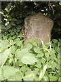
Old Milestone by the A19, Doncaster Road, Brayton parish
Carved stone post by the A19, in parish of BRAYTON (SELBY District), Doncaster Road, North of Burn village, 100m North of Common Lane, on narrow verge near Burn Grange, under hedge, on East side of road. Askern stone, erected by the Doncaster & Selby (New Trust) turnpike trust in the 19th century.
Inscription reads:-
DONCASTER
17½ MILES
ASKERN 10½
SELBY 2½
YORK 17
Carved benchmark on left face.
Grade II listed.
List Entry Number: 1296820 https://historicengland.org.uk/listing/the-list/list-entry/1296820
Milestone Society National ID: YN_DNSY17.
Image: © C Minto
Taken: 1 Mar 1993
0.06 miles
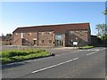
5
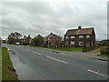
Burn Grange Cottage
Cottages on the west side of the A19 Doncaster Road, between Burn village and the Selby Canal.
Image: © Paul Glazzard
Taken: 5 Apr 2008
0.09 miles
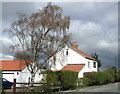
7
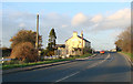
Burn, North Yorkshire
A small village in North Yorkshire. My mother came from here and my maternal grandparents lived in the first house on the right. The adjoining house was occupied by an aunt and uncle with their children. The houses as built had coal burning ranges in the living room for cooking, a proper cool pantry and a range of outhouses including a coal hole and a proper wash house with coal-fired copper, dolly peg and washboard. The outbuildings still survive on this pair.
Image: © Chris Allen
Taken: 25 Nov 2012
0.19 miles
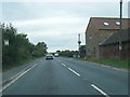
8
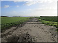
Track off Common Lane, Burn
This track is a public footpath and provides access to Burn Airfield.
Image: © Jonathan Thacker
Taken: 11 Jan 2017
0.22 miles
9
Disused pub at Burn Bridge on the A19
Image: © Bill Henderson
Taken: 20 Nov 2006
0.22 miles