IMAGES TAKEN NEAR TO
Common Road, SELBY, YO8 8JF
Introduction
This page details the photographs taken nearby to Common Road, YO8 8JF by members of the Geograph project.
The Geograph project started in 2005 with the aim of publishing, organising and preserving representative images for every square kilometre of Great Britain, Ireland and the Isle of Man.

There are currently over 7.5m images from over14,400 individuals and you can help contribute to the project by visiting https://www.geograph.org.uk
Image Map
Images are licensed for reuse under creativecommons.org/licenses/by-sa/2.0
Notes
- Clicking on the map will re-center to the selected point.
- The higher the marker number, the further away the image location is from the centre of the postcode.
Image Listing (13 Images Found)
Images are licensed for reuse under creativecommons.org/licenses/by-sa/2.0
Image
Details
Distance
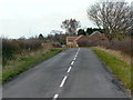
2
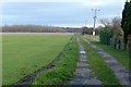
Farm access track
Looking north from Barlow Common Lane.
Image: © Alan Murray-Rust
Taken: 28 Dec 2018
0.09 miles
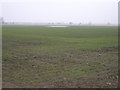
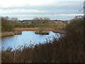
5
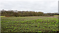
Field with leafy crop
The view is across a field with a crop (unknown to the photographer), with the trees and scrubland of Barlow Common beyond.
Image: © Trevor Littlewood
Taken: 5 Mar 2017
0.14 miles
6
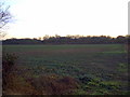
Woodland
This woodland scene is to be found opposite the row of houses between Barlow Lodge and Commonside Farm.
Image: © Brian C Payne
Taken: 15 Jan 2007
0.17 miles
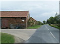
8
Commonside Farm
On Barlow Common Lane.
Image: © Alan Murray-Rust
Taken: 26 Dec 2011
0.20 miles
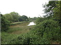
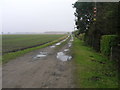
10
Pond on Barlow Common
Bracken House Farm in the distance.
Image: © Alan Murray-Rust
Taken: 26 Dec 2011
0.23 miles