IMAGES TAKEN NEAR TO
Brigg Lane, SELBY, YO8 8HJ
Introduction
This page details the photographs taken nearby to Brigg Lane, YO8 8HJ by members of the Geograph project.
The Geograph project started in 2005 with the aim of publishing, organising and preserving representative images for every square kilometre of Great Britain, Ireland and the Isle of Man.

There are currently over 7.5m images from over14,400 individuals and you can help contribute to the project by visiting https://www.geograph.org.uk
Image Map
Images are licensed for reuse under creativecommons.org/licenses/by-sa/2.0
Notes
- Clicking on the map will re-center to the selected point.
- The higher the marker number, the further away the image location is from the centre of the postcode.
Image Listing (31 Images Found)
Images are licensed for reuse under creativecommons.org/licenses/by-sa/2.0
Image
Details
Distance


7
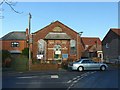
Camblesforth Village Church
Part of the local Methodist Circuit it is the only place of worship in the village and provides ecumenical worship.
Image: © Alan Murray-Rust
Taken: 28 Dec 2018
0.03 miles
8
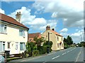
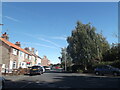
Camblesforth, Brigg Lane
Brigg Lane is the main road through Camblesforth Village to Drax Village.
The east end of the road was diverted in 1960s to make way for Drax Power Station
Image: © Gordon Kneale Brooke
Taken: 25 Oct 2005
0.03 miles
10

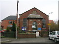
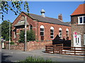
Wesleyan Chapel, Camblesforth
Erected in 1894
Image: © Ian S
Taken: 5 Aug 2012
0.03 miles