IMAGES TAKEN NEAR TO
Abbots Road, SELBY, YO8 8AT
Introduction
This page details the photographs taken nearby to Abbots Road, YO8 8AT by members of the Geograph project.
The Geograph project started in 2005 with the aim of publishing, organising and preserving representative images for every square kilometre of Great Britain, Ireland and the Isle of Man.

There are currently over 7.5m images from over14,400 individuals and you can help contribute to the project by visiting https://www.geograph.org.uk
Image Map
Images are licensed for reuse under creativecommons.org/licenses/by-sa/2.0
Notes
- Clicking on the map will re-center to the selected point.
- The higher the marker number, the further away the image location is from the centre of the postcode.
Image Listing (8 Images Found)
Images are licensed for reuse under creativecommons.org/licenses/by-sa/2.0
Image
Details
Distance
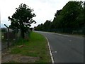
2
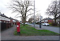
Abbot's Road, Selby
Showing position of Postbox No. YO8 71.
See Image] for postbox.
Image: © JThomas
Taken: 1 Feb 2020
0.22 miles
3
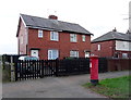
House on Abbot's Road, Selby
Showing position of Postbox No. YO8 71.
See Image] for postbox.
Image: © JThomas
Taken: 1 Feb 2020
0.23 miles
4
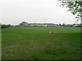
A Tate and Lyle Factory on the Outskirts of Selby
The photograph shows only part of the factory on Dennison Lane
Image: © Roger Gilbertson
Taken: 9 Jul 2006
0.23 miles
6
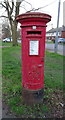
George VI postbox on Abbot's Road, Selby
Image: © JThomas
Taken: 1 Feb 2020
0.24 miles

8

The Boy & Barrel, Selby
On Woodville Terrace.
Image: © JThomas
Taken: 1 Feb 2020
0.24 miles