IMAGES TAKEN NEAR TO
South Duffield, SELBY, YO8 6TQ
Introduction
This page details the photographs taken nearby to YO8 6TQ by members of the Geograph project.
The Geograph project started in 2005 with the aim of publishing, organising and preserving representative images for every square kilometre of Great Britain, Ireland and the Isle of Man.

There are currently over 7.5m images from over14,400 individuals and you can help contribute to the project by visiting https://www.geograph.org.uk
Image Map
Images are licensed for reuse under creativecommons.org/licenses/by-sa/2.0
Notes
- Clicking on the map will re-center to the selected point.
- The higher the marker number, the further away the image location is from the centre of the postcode.
Image Listing (23 Images Found)
Images are licensed for reuse under creativecommons.org/licenses/by-sa/2.0
Image
Details
Distance
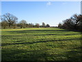
3
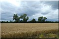
Barley along Dyon Lane
Looking across a field of barley beside Dyon Lane.
Image: © DS Pugh
Taken: 7 Aug 2021
0.08 miles
4
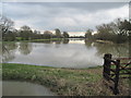
Dyon Drain has Flooded
The drain goes to the left of this flooded field along the tree line.
Image: © Martin Dawes
Taken: 19 Feb 2014
0.08 miles
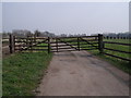
5
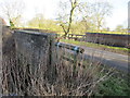
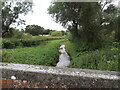
Dyon Bridge
Carries Dyon Lane across Dyon Drain.
Image: © Jonathan Thacker
Taken: 14 Jan 2017
0.09 miles
6
Dyon Bridge on Dyon Lane
Over Dyon Drain.
Image: © Martin Dawes
Taken: 19 Feb 2014
0.09 miles
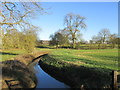
7
The Dyon
Contrast this with Martin Dawes photograph Image
Image: © Jonathan Thacker
Taken: 14 Jan 2017
0.09 miles
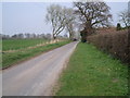
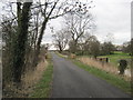
10
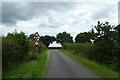
Uneven road and double bend
Looking along Dyon Lane.
Image: © DS Pugh
Taken: 7 Aug 2021
0.15 miles