IMAGES TAKEN NEAR TO
Durham Close, SELBY, YO8 6RG
Introduction
This page details the photographs taken nearby to Durham Close, YO8 6RG by members of the Geograph project.
The Geograph project started in 2005 with the aim of publishing, organising and preserving representative images for every square kilometre of Great Britain, Ireland and the Isle of Man.

There are currently over 7.5m images from over14,400 individuals and you can help contribute to the project by visiting https://www.geograph.org.uk
Image Map
Images are licensed for reuse under creativecommons.org/licenses/by-sa/2.0
Notes
- Clicking on the map will re-center to the selected point.
- The higher the marker number, the further away the image location is from the centre of the postcode.
Image Listing (33 Images Found)
Images are licensed for reuse under creativecommons.org/licenses/by-sa/2.0
Image
Details
Distance

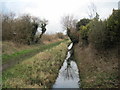
3

Oldways Lane
Follows an old course of the River Ouse.
Image: © Jonathan Thacker
Taken: 15 Apr 2017
0.12 miles
4
Oldways Lane (track)
This was the old route of the River Ouse.
Image: © Martin Dawes
Taken: 19 Feb 2014
0.13 miles
5

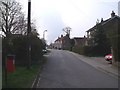
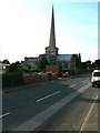
Approaching Hemingbrough on Landing Lane
Suburban housing forms the southern fringe of the village.
Image: © Jonathan Thacker
Taken: 15 Apr 2017
0.13 miles
6
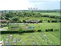
Hemingbrough
View South from the church tower showing Drax power station in the background and the Churchyard in the foreground.
Image: © Paul Allison
Taken: Unknown
0.17 miles
7

Path to Fishing Pond
Behind the trees is a large pond.
Image: © Martin Dawes
Taken: 19 Feb 2014
0.17 miles
10

Barmby Ferry Road
Looking towards the edge of Hemingbrough.
Image: © Jonathan Thacker
Taken: 15 Apr 2017
0.21 miles