IMAGES TAKEN NEAR TO
Chestnut Garth, SELBY, YO8 6RB
Introduction
This page details the photographs taken nearby to Chestnut Garth, YO8 6RB by members of the Geograph project.
The Geograph project started in 2005 with the aim of publishing, organising and preserving representative images for every square kilometre of Great Britain, Ireland and the Isle of Man.

There are currently over 7.5m images from over14,400 individuals and you can help contribute to the project by visiting https://www.geograph.org.uk
Image Map
Images are licensed for reuse under creativecommons.org/licenses/by-sa/2.0
Notes
- Clicking on the map will re-center to the selected point.
- The higher the marker number, the further away the image location is from the centre of the postcode.
Image Listing (39 Images Found)
Images are licensed for reuse under creativecommons.org/licenses/by-sa/2.0
Image
Details
Distance
1
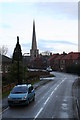
Finkle Street
Photograph shows Finkle (bend) in Finkle Street, the bend in the road is to follow the contour of the land which falls away in both directions from the side of the road.
Image: © ken mccann
Taken: 12 Jan 2008
0.13 miles
2

Water Lane, Hemingbrough
Looking towards the junction with the A63.
Image: © DS Pugh
Taken: 7 Aug 2021
0.13 miles

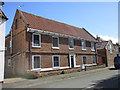
4
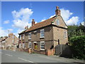
Hawthorn House, Hemingbrough
Late eighteenth century house http://www.britishlistedbuildings.co.uk/101296618-hawthorn-house-hemingbrough#.WPKcWqK1tpw
Image: © Jonathan Thacker
Taken: 15 Apr 2017
0.17 miles
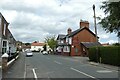
5
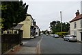
Main Street
Looking along Main Street in Hemingbrough next to The Crown public house.
Image: © DS Pugh
Taken: 21 Jul 2013
0.18 miles
6
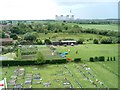
Hemingbrough
View South from the church tower showing Drax power station in the background and the Churchyard in the foreground.
Image: © Paul Allison
Taken: Unknown
0.18 miles
7
Church Farmhouse, Hemingbrough
Mid eighteenth century house. http://www.britishlistedbuildings.co.uk/101316308-church-farmhouse-hemingbrough#.WPKauKK1tpw
Image: © Jonathan Thacker
Taken: 15 Apr 2017
0.18 miles
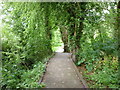
8

Boardwalk through conservation area
Boardwalk raised above ground level and water level through conservation area linking to public footpath network
Image: © ken mccann
Taken: 24 Mar 2007
0.19 miles
10
The Fox & Pheasant
Looking along Main Street, Hemingbrough.
Image: © DS Pugh
Taken: 7 Aug 2021
0.19 miles