IMAGES TAKEN NEAR TO
Foggathorpe, SELBY, YO8 6PR
Introduction
This page details the photographs taken nearby to YO8 6PR by members of the Geograph project.
The Geograph project started in 2005 with the aim of publishing, organising and preserving representative images for every square kilometre of Great Britain, Ireland and the Isle of Man.

There are currently over 7.5m images from over14,400 individuals and you can help contribute to the project by visiting https://www.geograph.org.uk
Image Map
Images are licensed for reuse under creativecommons.org/licenses/by-sa/2.0
Notes
- Clicking on the map will re-center to the selected point.
- The higher the marker number, the further away the image location is from the centre of the postcode.
Image Listing (27 Images Found)
Images are licensed for reuse under creativecommons.org/licenses/by-sa/2.0
Image
Details
Distance
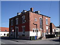
1
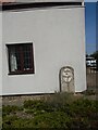
Old milestone
This milestone near the crossroads of the minor road from Seaton Ross to the north and the main Selby to Market Weighton Road is in front of White House Cottage. The stone was once painted the same as the house walls. It is another milestone probably dating from the turnpike era. The Selby Ferry to Market Weighton tollroad was operative between 1793 to 1879 so this stone may date from the early to mid 19C. There is a bench mark and hole (for a metal peg) in the top edge. It is Grade II Listed 165265.
Image: © Chris Minto
Taken: 10 Apr 2022
0.00 miles
2
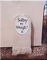
Old Milestone, on the A163, outside White House Cottage
Located on the North side of road, in gravel beside house wall. Metal plate attached to stone post, oval plate design, 18th/19th century.
Inscription reads: Selby / 10 / Weighᴺ. / 8
Grade II listed by Historic England.
Milestone Society National ID: YE_SYMW10
Image: © John Harland
Taken: 1 Jan 2006
0.00 miles
6
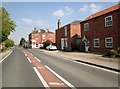
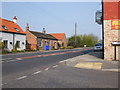
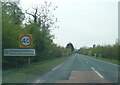
A163 passing through Foggathorpe
The main part of the village is to the right on the road down to the dismantled railway. Foggathorpe had a station from 1851 to 1954 when passenger service was withdrawn
Image: © Martin Dawes
Taken: 10 May 2017
0.02 miles
7
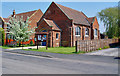
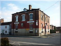
The Chapel, Foggathorpe, East Yorks.
This red brick building blends well with the surrounding built environment.
Image: © Peter Church
Taken: 8 May 2008
0.07 miles
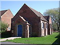
10
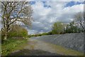
Gravel storage
Looking along part of the Bubwith Rail Trail built on the former railway line.
Image: © DS Pugh
Taken: 22 Apr 2017
0.19 miles