IMAGES TAKEN NEAR TO
Green Lane, SELBY, YO8 6PG
Introduction
This page details the photographs taken nearby to Green Lane, YO8 6PG by members of the Geograph project.
The Geograph project started in 2005 with the aim of publishing, organising and preserving representative images for every square kilometre of Great Britain, Ireland and the Isle of Man.

There are currently over 7.5m images from over14,400 individuals and you can help contribute to the project by visiting https://www.geograph.org.uk
Image Map
Images are licensed for reuse under creativecommons.org/licenses/by-sa/2.0
Notes
- Clicking on the map will re-center to the selected point.
- The higher the marker number, the further away the image location is from the centre of the postcode.
Image Listing (19 Images Found)
Images are licensed for reuse under creativecommons.org/licenses/by-sa/2.0
Image
Details
Distance
2
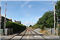
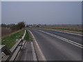
Train line through Cliffe
Looking towards Selby and York at the level crossing in Cliffe.
Image: © Dave Pickersgill
Taken: 1 Aug 2015
0.11 miles
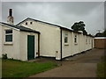
6

Cliffe Institute
The benchmark is cut into the south-east facing wall of the building. The mark has been slightly damaged by layers of masonry paint.
Image: © Mel Towler
Taken: 23 Mar 2022
0.20 miles
7
Cliffe Institute
There is a benchmark cut into the south-east facing wall of the building. The mark has been slightly damaged by layers of masonry paint.
Image: © Mel Towler
Taken: 23 Mar 2022
0.20 miles
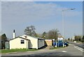
10
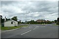
Main Street junction with the A63
The junction with Hull Road in Cliffe.
Image: © DS Pugh
Taken: 7 Aug 2021
0.22 miles