IMAGES TAKEN NEAR TO
Station Road, SELBY, YO8 6EW
Introduction
This page details the photographs taken nearby to Station Road, YO8 6EW by members of the Geograph project.
The Geograph project started in 2005 with the aim of publishing, organising and preserving representative images for every square kilometre of Great Britain, Ireland and the Isle of Man.

There are currently over 7.5m images from over14,400 individuals and you can help contribute to the project by visiting https://www.geograph.org.uk
Image Map
Images are licensed for reuse under creativecommons.org/licenses/by-sa/2.0
Notes
- Clicking on the map will re-center to the selected point.
- The higher the marker number, the further away the image location is from the centre of the postcode.
Image Listing (44 Images Found)
Images are licensed for reuse under creativecommons.org/licenses/by-sa/2.0
Image
Details
Distance
1

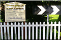
Parish Church of St John of Beverley, Wressle
Image: © Charles Rispin
Taken: 26 Sep 2006
0.03 miles
3
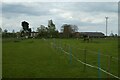
Horses near Mill Farm
Looking towards the windmill in Wressle.
Image: © DS Pugh
Taken: 30 Apr 2022
0.05 miles
4
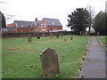
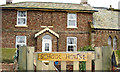
Churchyard and former school, Wressle
Image: © Jonathan Thacker
Taken: 30 Dec 2011
0.07 miles
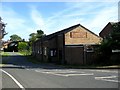
8
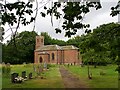
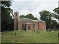
Church of St John of Beverley
Grade II listed parish church built in 1799 on the site of the ancient parish church of Wressell (the spelling of the village name has changed since then)
Image: © Graham Hogg
Taken: 27 Jun 2022
0.09 miles
10
St John of Beverley. Wressle Parish Church
Image: © Martin Dawes
Taken: 22 Jun 2010
0.10 miles