IMAGES TAKEN NEAR TO
Hall Park, SELBY, YO8 5XR
Introduction
This page details the photographs taken nearby to Hall Park, YO8 5XR by members of the Geograph project.
The Geograph project started in 2005 with the aim of publishing, organising and preserving representative images for every square kilometre of Great Britain, Ireland and the Isle of Man.

There are currently over 7.5m images from over14,400 individuals and you can help contribute to the project by visiting https://www.geograph.org.uk
Image Map
Images are licensed for reuse under creativecommons.org/licenses/by-sa/2.0
Notes
- Clicking on the map will re-center to the selected point.
- The higher the marker number, the further away the image location is from the centre of the postcode.
Image Listing (44 Images Found)
Images are licensed for reuse under creativecommons.org/licenses/by-sa/2.0
Image
Details
Distance
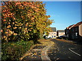
2
York Road
Looking along York Road towards Hall Park in the rain.
Image: © DS Pugh
Taken: 2 Jan 2022
0.03 miles


7
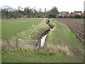
Bendy clough
Draining land at Barlby Hilltop
Image: © Malcolm Campbell
Taken: 21 Feb 2008
0.07 miles
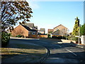
8
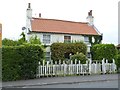
Old Toll House by York Road, Barlby
Barlby Toll House by the UC road, in parish of Selby (Selby District), The Old Toll House, Mount Pleasant, York Road, junction with Landing Lane.
Surveyed
Milestone Society National ID: YN.SEL03
Image: © Alan Rosevear
Taken: 13 Jun 2014
0.08 miles
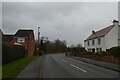
9
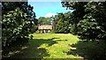
Barlby Hall
Probably built in 1830s on the site of an older building
Image: © Chris Morgan
Taken: 30 Aug 2016
0.09 miles