IMAGES TAKEN NEAR TO
Skipwith, SELBY, YO8 5SW
Introduction
This page details the photographs taken nearby to YO8 5SW by members of the Geograph project.
The Geograph project started in 2005 with the aim of publishing, organising and preserving representative images for every square kilometre of Great Britain, Ireland and the Isle of Man.

There are currently over 7.5m images from over14,400 individuals and you can help contribute to the project by visiting https://www.geograph.org.uk
Image Map
Images are licensed for reuse under creativecommons.org/licenses/by-sa/2.0
Notes
- Clicking on the map will re-center to the selected point.
- The higher the marker number, the further away the image location is from the centre of the postcode.
Image Listing (8 Images Found)
Images are licensed for reuse under creativecommons.org/licenses/by-sa/2.0
Image
Details
Distance
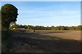
4
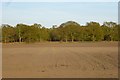
Fields at Birchwood Farm
Looking across from Bonby Lane towards Crook Moor.
Image: © DS Pugh
Taken: 4 May 2016
0.08 miles
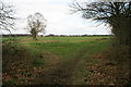
5
Bales near Birchwood Farm
A stack of bales stands beside Birchwood Farm, seen from Bonby Lane.
Image: © DS Pugh
Taken: 4 May 2016
0.10 miles
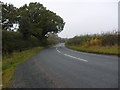
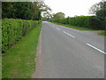
7
Which Way
The right fork of this path along the edge of Crook Moor towards Skipwith shows more use. Probably because the left fork officially reaches a dead end.
Image: © David Rogers
Taken: 4 Apr 2008
0.20 miles
8
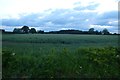
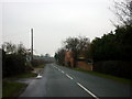
Towards Broomhill Plantation
From the road between Skipwith and Escrick.
Image: © DS Pugh
Taken: 21 Jun 2013
0.22 miles