IMAGES TAKEN NEAR TO
Cockret Lane, SELBY, YO8 4RT
Introduction
This page details the photographs taken nearby to Cockret Lane, YO8 4RT by members of the Geograph project.
The Geograph project started in 2005 with the aim of publishing, organising and preserving representative images for every square kilometre of Great Britain, Ireland and the Isle of Man.

There are currently over 7.5m images from over14,400 individuals and you can help contribute to the project by visiting https://www.geograph.org.uk
Image Map
Images are licensed for reuse under creativecommons.org/licenses/by-sa/2.0
Notes
- Clicking on the map will re-center to the selected point.
- The higher the marker number, the further away the image location is from the centre of the postcode.
Image Listing (7 Images Found)
Images are licensed for reuse under creativecommons.org/licenses/by-sa/2.0
Image
Details
Distance

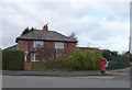
4
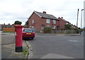
Houses on Charles Street, Selby
Showing position of Postbox No. YO8 78.
See Image] for postbox.
Image: © JThomas
Taken: 1 Feb 2020
0.21 miles
5
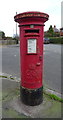
George V postbox on Charles Street, Selby
Image: © JThomas
Taken: 1 Feb 2020
0.22 miles
6
Houses on Charles Street, Selby
Showing position of Postbox No. YO8 78.
See Image] for postbox.
Image: © JThomas
Taken: 1 Feb 2020
0.23 miles
7
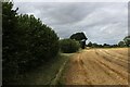
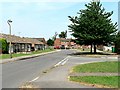
Footpath heading for Olive Bush Farm on Sherburn Road
The footpath seems to be on the wrong side of the hedge, according to the map.
The right of way between the northern outskirts of Selby and Sherburn road.
Image: © Chris Heaton
Taken: 19 Aug 2023
0.24 miles