IMAGES TAKEN NEAR TO
Cedar Crescent, SELBY, YO8 4JW
Introduction
This page details the photographs taken nearby to Cedar Crescent, YO8 4JW by members of the Geograph project.
The Geograph project started in 2005 with the aim of publishing, organising and preserving representative images for every square kilometre of Great Britain, Ireland and the Isle of Man.

There are currently over 7.5m images from over14,400 individuals and you can help contribute to the project by visiting https://www.geograph.org.uk
Image Map
Images are licensed for reuse under creativecommons.org/licenses/by-sa/2.0
Notes
- Clicking on the map will re-center to the selected point.
- The higher the marker number, the further away the image location is from the centre of the postcode.
Image Listing (13 Images Found)
Images are licensed for reuse under creativecommons.org/licenses/by-sa/2.0
Image
Details
Distance
2
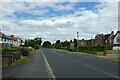
Towards Selby on Leeds Road
Looking along Leeds Road, the A1238 heading into Selby from the west.
Image: © DS Pugh
Taken: 13 Jun 2021
0.13 miles


7
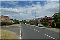
Junction with Holden Gardens
Looking along Leeds Road on the edge of Selby.
Image: © DS Pugh
Taken: 13 Jun 2021
0.21 miles
8

Leeds Road (A1238), Selby
Showing position of Postbox No. YO8 79.
See Image] for postbox.
Image: © JThomas
Taken: 1 Feb 2020
0.22 miles

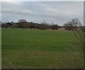
10

The view from Fox Hill Lane
A contribution to the Christmas Midday set for 2013
Image: © Alan Murray-Rust
Taken: 25 Dec 2013
0.23 miles