IMAGES TAKEN NEAR TO
Castle Close, SELBY, YO8 3SY
Introduction
This page details the photographs taken nearby to Castle Close, YO8 3SY by members of the Geograph project.
The Geograph project started in 2005 with the aim of publishing, organising and preserving representative images for every square kilometre of Great Britain, Ireland and the Isle of Man.

There are currently over 7.5m images from over14,400 individuals and you can help contribute to the project by visiting https://www.geograph.org.uk
Image Map
Images are licensed for reuse under creativecommons.org/licenses/by-sa/2.0
Notes
- Clicking on the map will re-center to the selected point.
- The higher the marker number, the further away the image location is from the centre of the postcode.
Image Listing (34 Images Found)
Images are licensed for reuse under creativecommons.org/licenses/by-sa/2.0
Image
Details
Distance

2

Sherburn Street (B1222), Cawood
Showing position of Postbox No. YO8 46.
See Image] for postbox.
Image: © JThomas
Taken: 1 Feb 2020
0.06 miles
3
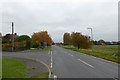
Sherburn Street
Entering Cawood on the B1222.
Image: © DS Pugh
Taken: 30 Oct 2016
0.07 miles
4
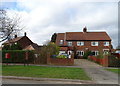
Houses on Sherburn Street, Cawood
Showing position of Postbox No. YO8 46.
See Image] for postbox.
Image: © JThomas
Taken: 1 Feb 2020
0.07 miles
5
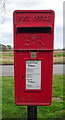
Elizabeth II postbox on Sherburn Street, Cawood
Image: © JThomas
Taken: 1 Feb 2020
0.08 miles
6
Site of Cawood station, 1988
View NW along track-bed to former terminus: ex-NER branch from Selby, built as a Light Railway and closed 1/1/30 to passengers, 2/5/60 to goods.
Image: © Ben Brooksbank
Taken: 24 Jun 1988
0.08 miles
7

Sherburn Street (B1222), Cawood
Showing position of Postbox No. YO8 46.
See Image] for postbox.
Image: © JThomas
Taken: 1 Feb 2020
0.09 miles
8
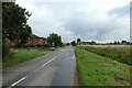
Edge of Cawood
Looking along the B1222 just south of Cawood.
Image: © DS Pugh
Taken: 22 Aug 2021
0.09 miles
9
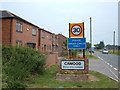
Welcome to Cawood
This is the point where Cawood's development now begins. It is recent development on the west side of the B1222 road only in the southwest corner of the town. Cawood (pronounced Kaywood) is about 4 miles northwest of Selby on the River Ouse and grew up in a strategic position near the confluence with the River Wharfe, in effect, the last outpost of Wharfedale.
Image: © michael ely
Taken: 6 Jul 2006
0.10 miles
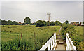
10
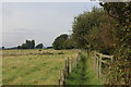
Footpath to Fostergate Lane
Path between Fostergate Lane and the B1222
Image: © Chris Heaton
Taken: 5 Oct 2019
0.13 miles