IMAGES TAKEN NEAR TO
Wistowgate, SELBY, YO8 3SJ
Introduction
This page details the photographs taken nearby to Wistowgate, YO8 3SJ by members of the Geograph project.
The Geograph project started in 2005 with the aim of publishing, organising and preserving representative images for every square kilometre of Great Britain, Ireland and the Isle of Man.

There are currently over 7.5m images from over14,400 individuals and you can help contribute to the project by visiting https://www.geograph.org.uk
Image Map
Images are licensed for reuse under creativecommons.org/licenses/by-sa/2.0
Notes
- Clicking on the map will re-center to the selected point.
- The higher the marker number, the further away the image location is from the centre of the postcode.
Image Listing (34 Images Found)
Images are licensed for reuse under creativecommons.org/licenses/by-sa/2.0
Image
Details
Distance

2
Nicky Nacky Lane, Cawood
Showing position of Postbox No. YO8 69.
See Image] for postbox.
Image: © JThomas
Taken: 1 Feb 2020
0.08 miles
4
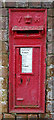
Victorian postbox on Wistowgate, Cawood
Image: © JThomas
Taken: 1 Feb 2020
0.09 miles
5
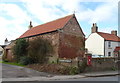
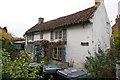
Old building on Wistowgate, Cawood
Showing position of Postbox No. YO8 69.
See Image] for postbox.
Image: © JThomas
Taken: 1 Feb 2020
0.09 miles
6
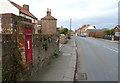
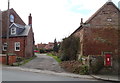
Wistowgate, Cawood
Showing position of Postbox No. YO8 69.
See Image] for postbox.
Image: © JThomas
Taken: 1 Feb 2020
0.11 miles
8

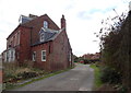
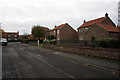
Farmland off the B1223
A field of stubble beside the B1223 between Cawood and Wistow.
Image: © DS Pugh
Taken: 29 Oct 2017
0.14 miles