IMAGES TAKEN NEAR TO
Thorpe Wood, SELBY, YO8 3RG
Introduction
This page details the photographs taken nearby to YO8 3RG by members of the Geograph project.
The Geograph project started in 2005 with the aim of publishing, organising and preserving representative images for every square kilometre of Great Britain, Ireland and the Isle of Man.

There are currently over 7.5m images from over14,400 individuals and you can help contribute to the project by visiting https://www.geograph.org.uk
Image Map
Images are licensed for reuse under creativecommons.org/licenses/by-sa/2.0
Notes
- Clicking on the map will re-center to the selected point.
- The higher the marker number, the further away the image location is from the centre of the postcode.
Image Listing (6 Images Found)
Images are licensed for reuse under creativecommons.org/licenses/by-sa/2.0
Image
Details
Distance
2
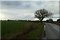
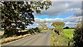
Tree beside Dam Lane
Looking along Dam Lane between Thorpe Willoughby and Selby.
Image: © DS Pugh
Taken: 18 Mar 2023
0.20 miles
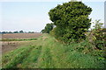
3
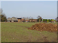
Muck heap and Portland Lodge
Seen from the footpath between Thorpe Hall and Crosshills Farm, part of the Selby Horseshoe walk.
Image: © Alan Murray-Rust
Taken: 25 Dec 2013
0.23 miles