1
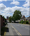
New Millgate (B1223), Selby
Image: © habiloid
Taken: 26 Jun 2022
0.01 miles
2
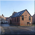
Millgate at Flaxley Road and New Millgate
The large red building is variously marked on old maps as Mission Hall or Institute, and certainly gives the impression of religious origins. It is now apartments under the name of Old School Lofts. It has a bench mark http://www.geograph.org.uk/photo/3797440 on the near corner.
Image: © Alan Murray-Rust
Taken: 26 Dec 2013
0.02 miles
3
Bench mark, Old School Lofts, Millgate
See http://www.geograph.org.uk/photo/3797435 for location view.
Image: © Alan Murray-Rust
Taken: 26 Dec 2013
0.03 miles
4
Millgate (B1223), Selby
Image: © habiloid
Taken: 26 Jun 2022
0.03 miles
5
83 & 85 Millgate
83 is the 3-bay house, 85 the nearer building with the archway. The latter leads through to Simpsons Court which would have been surrounded by its own dwellings. Both are mid 19th century and are Listed Grade II.
Image: © Alan Murray-Rust
Taken: 26 Dec 2013
0.06 miles
6
Millgate looking east from Crank Corner
Crank Corner is the name of the location which appears on a 1891 town plan.
This was originally the main road towards Cawood until a new road (New Millgate) was created in the late 20th century at the back of the left hand houses, and the lower end of Millgate itself became a cul-de-sac. The street is a designated Conservation area, and the first group of houses on the left of the picture, dating from the early 19th century, are Listed Grade II.
Image: © Alan Murray-Rust
Taken: 26 Dec 2013
0.06 miles
7
Millgate looking west from Friendship Court
The set of houses beginning from the red door date from the early 19th century and are Listed Grade II.
Image: © Alan Murray-Rust
Taken: 26 Dec 2013
0.06 miles
8
St Michael's Chapel, Millgate
This is a 1903 rebuild of an earlier (1699) chapel. Old maps show it as Unitarian, but Unitarianism in England only dates back to the latter part of the 18th century. Now a dwelling.
Image: © Alan Murray-Rust
Taken: 26 Dec 2013
0.06 miles
9
Service station on Millgate, Selby
Image: © JThomas
Taken: 1 Feb 2020
0.06 miles
10
Dobsons Row
A row of early 19th A row of 7 (originally 8, but the nearest one was demolished at some stage to improve Millgate) cottages from the early 19th century off Millgate. They are Listed Grade II and have been carefully restored, even to the extent of being given a matching set of new tall chimney pots.
Image: © Alan Murray-Rust
Taken: 26 Dec 2013
0.06 miles


