IMAGES TAKEN NEAR TO
Millgate, SELBY, YO8 3LD
Introduction
This page details the photographs taken nearby to Millgate, YO8 3LD by members of the Geograph project.
The Geograph project started in 2005 with the aim of publishing, organising and preserving representative images for every square kilometre of Great Britain, Ireland and the Isle of Man.

There are currently over 7.5m images from over14,400 individuals and you can help contribute to the project by visiting https://www.geograph.org.uk
Image Map
Images are licensed for reuse under creativecommons.org/licenses/by-sa/2.0
Notes
- Clicking on the map will re-center to the selected point.
- The higher the marker number, the further away the image location is from the centre of the postcode.
Image Listing (316 Images Found)
Images are licensed for reuse under creativecommons.org/licenses/by-sa/2.0
Image
Details
Distance
1
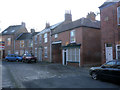
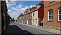
83 & 85 Millgate
83 is the 3-bay house, 85 the nearer building with the archway. The latter leads through to Simpsons Court which would have been surrounded by its own dwellings. Both are mid 19th century and are Listed Grade II.
Image: © Alan Murray-Rust
Taken: 26 Dec 2013
0.01 miles
2
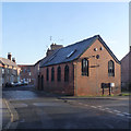
St Michael's Chapel, Millgate
This is a 1903 rebuild of an earlier (1699) chapel. Old maps show it as Unitarian, but Unitarianism in England only dates back to the latter part of the 18th century. Now a dwelling.
Image: © Alan Murray-Rust
Taken: 26 Dec 2013
0.02 miles
3
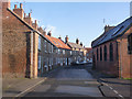
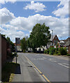
Millgate looking east from Crank Corner
Crank Corner is the name of the location which appears on a 1891 town plan.
This was originally the main road towards Cawood until a new road (New Millgate) was created in the late 20th century at the back of the left hand houses, and the lower end of Millgate itself became a cul-de-sac. The street is a designated Conservation area, and the first group of houses on the left of the picture, dating from the early 19th century, are Listed Grade II.
Image: © Alan Murray-Rust
Taken: 26 Dec 2013
0.03 miles
4
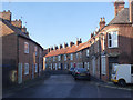
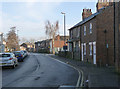
Millgate looking west from Friendship Court
The set of houses beginning from the red door date from the early 19th century and are Listed Grade II.
Image: © Alan Murray-Rust
Taken: 26 Dec 2013
0.03 miles
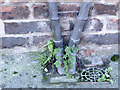
6
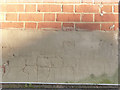
Bench mark, Old School Lofts, Millgate
See http://www.geograph.org.uk/photo/3797435 for location view.
Image: © Alan Murray-Rust
Taken: 26 Dec 2013
0.04 miles
7

Millgate at Flaxley Road and New Millgate
The large red building is variously marked on old maps as Mission Hall or Institute, and certainly gives the impression of religious origins. It is now apartments under the name of Old School Lofts. It has a bench mark http://www.geograph.org.uk/photo/3797440 on the near corner.
Image: © Alan Murray-Rust
Taken: 26 Dec 2013
0.05 miles
9
Flaxley Road at Dam Bank
Dam Bank is the opening at the right hand side. The pair of cottages with white doors are marked on an 1849 town map as "Feoffees", who were responsible for the poor of the town and would have been let as charity housing.
There is a bench mark http://www.geograph.org.uk/photo/3797432 in the centre of the façade of these two.
Image: © Alan Murray-Rust
Taken: 26 Dec 2013
0.07 miles
10
Bench mark, #13/15 Flaxley Road
See http://www.geograph.org.uk/photo/3797399 for location view.
Image: © Alan Murray-Rust
Taken: 26 Dec 2013
0.07 miles