IMAGES TAKEN NEAR TO
Firth Mews, Millgate, SELBY, YO8 3FZ
Introduction
This page details the photographs taken nearby to Firth Mews, Millgate, YO8 3FZ by members of the Geograph project.
The Geograph project started in 2005 with the aim of publishing, organising and preserving representative images for every square kilometre of Great Britain, Ireland and the Isle of Man.

There are currently over 7.5m images from over14,400 individuals and you can help contribute to the project by visiting https://www.geograph.org.uk
Image Map
Images are licensed for reuse under creativecommons.org/licenses/by-sa/2.0
Notes
- Clicking on the map will re-center to the selected point.
- The higher the marker number, the further away the image location is from the centre of the postcode.
Image Listing (505 Images Found)
Images are licensed for reuse under creativecommons.org/licenses/by-sa/2.0
Image
Details
Distance
1

Firth Mews - Millgate
This is an Anchor Housing complex.
Image: © Betty Longbottom
Taken: 11 Jun 2014
0.01 miles
2
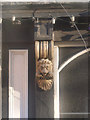
A Golden Lion
Lion-mask console on the façade of The Golden Lion pub http://www.geograph.org.uk/photo/3797517
Image: © Alan Murray-Rust
Taken: 26 Dec 2013
0.03 miles
3
The lower end of Millgate
The modern mill in the background doesn't seem to have developed directly from whatever earlier mill gave Millgate its name.
Image: © Alan Murray-Rust
Taken: 26 Dec 2013
0.03 miles
4
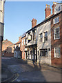
The Golden Lion, Millgate
Late 19th century public house, retaining its original frontage. The pub and the house to this side of it, part of which has merged into the pub and is much altered, are Listed Grade II. See also http://www.geograph.org.uk/photo/3797512
Image: © Alan Murray-Rust
Taken: 26 Dec 2013
0.04 miles
5
Millgate - viewed from Alma Terrace
Image: © Betty Longbottom
Taken: 11 Jun 2014
0.04 miles
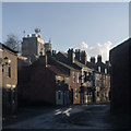
6
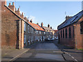
Millgate looking east from Crank Corner
Crank Corner is the name of the location which appears on a 1891 town plan.
This was originally the main road towards Cawood until a new road (New Millgate) was created in the late 20th century at the back of the left hand houses, and the lower end of Millgate itself became a cul-de-sac. The street is a designated Conservation area, and the first group of houses on the left of the picture, dating from the early 19th century, are Listed Grade II.
Image: © Alan Murray-Rust
Taken: 26 Dec 2013
0.04 miles
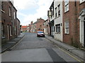
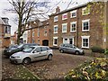
7
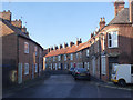
Millgate looking west from Friendship Court
The set of houses beginning from the red door date from the early 19th century and are Listed Grade II.
Image: © Alan Murray-Rust
Taken: 26 Dec 2013
0.04 miles
8
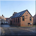
St Michael's Chapel, Millgate
This is a 1903 rebuild of an earlier (1699) chapel. Old maps show it as Unitarian, but Unitarianism in England only dates back to the latter part of the 18th century. Now a dwelling.
Image: © Alan Murray-Rust
Taken: 26 Dec 2013
0.05 miles
10
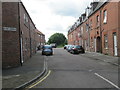
Millgate, Selby
Cul-de-sac end of the street, created by New Millgate which passes to the right of the pictured houses.
Image: © Paul Harrop
Taken: 24 Nov 2016
0.05 miles