IMAGES TAKEN NEAR TO
Catton, THIRSK, YO7 4SG
Introduction
This page details the photographs taken nearby to YO7 4SG by members of the Geograph project.
The Geograph project started in 2005 with the aim of publishing, organising and preserving representative images for every square kilometre of Great Britain, Ireland and the Isle of Man.

There are currently over 7.5m images from over14,400 individuals and you can help contribute to the project by visiting https://www.geograph.org.uk
Image Map (Loading...)


Getting Data...Please wait
Leaflet Map data © OpenStreetMap
Images are licensed for reuse under creativecommons.org/licenses/by-sa/2.0
Notes
- Clicking on the map will re-center to the selected point.
- The higher the marker number, the further away the image location is from the centre of the postcode.
Image Listing (4 Images Found)
Images are licensed for reuse under creativecommons.org/licenses/by-sa/2.0
Image
Details
Distance
1
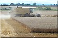
Combine at work, Catton
A busy time for arable farmers with crops ready for harvest and a change in the weather forecast. The 2018 cereal crop is said to be poorer than usual as the long period of drought has meant that the grains have been less well developed.
Image: © Gordon Hatton
Taken: 7 Aug 2018
0.07 miles
2
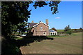
School House
Now a private residence - found on the narrow lane between Catton and Skipton-on-Swale
Image: © Chris Heaton
Taken: 20 Oct 2015
0.16 miles
3
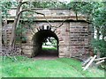
Remains of the old railway bridge
These are the visible remains of the old railway bridge over the Swale at Catton. The river is to the right and on the far bank there must be a similar structure, but in summer it is completely hidden by foliage. The bridge must date from circa 1848 which is when the branch from Melmerby Junction to Thirsk opened, the line finally closing to all traffic in 1966. Quite when the bridge was demolished is a mystery, as was its construction. If there are substantial sandstone structures either side of the river, was there a stone arch bridge or a metal girder bridge? The span would appear to be too far for a single stone arch, whilst there is no indication of any central pier in the river, so maybe there was a metal girder bridge. More investigation required to find the answer.
My 2005 edition of the 1:25000 map shows a footbridge here [later editions omit it], but a local resident was of the opinion that any bridge was merely for a pipe to cross the river.
Image: © Gordon Hatton
Taken: 12 Aug 2018
0.22 miles
4
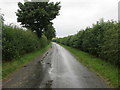
Catton Road heading towards Skipton-on-Swale
Looking northward.
Image: © Peter Wood
Taken: 3 Aug 2018
0.25 miles