IMAGES TAKEN NEAR TO
Skipton Bridge, THIRSK, YO7 4SB
Introduction
This page details the photographs taken nearby to YO7 4SB by members of the Geograph project.
The Geograph project started in 2005 with the aim of publishing, organising and preserving representative images for every square kilometre of Great Britain, Ireland and the Isle of Man.

There are currently over 7.5m images from over14,400 individuals and you can help contribute to the project by visiting https://www.geograph.org.uk
Image Map
Images are licensed for reuse under creativecommons.org/licenses/by-sa/2.0
Notes
- Clicking on the map will re-center to the selected point.
- The higher the marker number, the further away the image location is from the centre of the postcode.
Image Listing (47 Images Found)
Images are licensed for reuse under creativecommons.org/licenses/by-sa/2.0
Image
Details
Distance
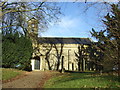
1
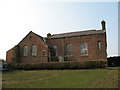
Disused chapel at Skipton on Swale
This strange building is located at the back of cottages and is approached by a footpath. It was difficult to decide if it was an old school or a chapel, but the map indicates the latter.
Image: © Gordon Hatton
Taken: 15 Apr 2007
0.02 miles
2
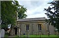
Skipton on Swale church
A wider angle taken almost from the church gate looking north. There is a benchmark cut into the stonework to the left of the main church access door. The mark is cut into the 3rd stone course and is south facing.
Image: © Mel Towler
Taken: 20 Aug 2021
0.03 miles
3
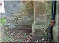
Skipton on Swale church
This benchmark is cut into the stonework to the left of the main church access door. The wall is south facing and the mark is cut into the 3rd stone course.
Image: © Mel Towler
Taken: 20 Aug 2021
0.03 miles
4
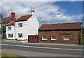
The Smithy
The former Smithy on the main street at Skipton on Swale.
Image: © David Rogers
Taken: 19 Jun 2008
0.04 miles
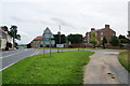
5
Looking West at Skipton on Swale
The white sign on the right and the roof over the hedge is the pet crematorium and in the centre of the photo among the trees is the church Image and on the left behind the houses is the Canadian Memorial Image
Image: © Nick W
Taken: 13 Jan 2008
0.04 miles
6
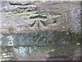
Ordnance Survey Cut Mark
This mark can be found on the wall of St John's Church in Skipton-on-Swale. The benchmark height is recorded as being 30.787 metres above sea level.
For more detail see : https://www.bench-marks.org.uk/bm32266
Image: © Peter Wood
Taken: 3 Aug 2018
0.05 miles
7
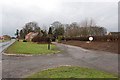
The village green, Skipton-on-Swale
There isn't much more in the village than this, but it is a strategic place, commanding a rare crossing of the Swale.
Image: © Bill Boaden
Taken: 23 Aug 2013
0.05 miles
9
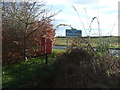
Elizabeth II postbox, Skipton-on-Swale
Just off the A61.
Postbox No. YO7 34.
See Image] for close up.
Image: © JThomas
Taken: 16 Dec 2017
0.05 miles
10
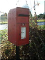
Close up, Elizabeth II postbox, Skipton-on-Swale
Just off the A61.
Postbox No. YO7 34.
See Image] for wider view.
Image: © JThomas
Taken: 16 Dec 2017
0.05 miles