IMAGES TAKEN NEAR TO
Pickhill, THIRSK, YO7 4JR
Introduction
This page details the photographs taken nearby to YO7 4JR by members of the Geograph project.
The Geograph project started in 2005 with the aim of publishing, organising and preserving representative images for every square kilometre of Great Britain, Ireland and the Isle of Man.

There are currently over 7.5m images from over14,400 individuals and you can help contribute to the project by visiting https://www.geograph.org.uk
Image Map
Images are licensed for reuse under creativecommons.org/licenses/by-sa/2.0
Notes
- Clicking on the map will re-center to the selected point.
- The higher the marker number, the further away the image location is from the centre of the postcode.
Image Listing (3 Images Found)
Images are licensed for reuse under creativecommons.org/licenses/by-sa/2.0
Image
Details
Distance
1
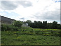
Footpath near Highfield Farm
There is a waymark on one of the fenceposts but no stile. Just keep to the right of the buildings!
Image: © John Slater
Taken: 25 Jun 2013
0.19 miles
2
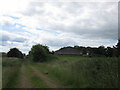
Approaching Manor Farm
Following the disused railway
Image: © John Slater
Taken: 25 Jun 2013
0.22 miles
3
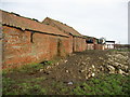
Buildings, Manor House Farm
Rather muddy going as I walked past this farm, situated about a mile north of Pickhill
Image: © Chris Heaton
Taken: 14 Feb 2007
0.23 miles