IMAGES TAKEN NEAR TO
Kirby Wiske, THIRSK, YO7 4EU
Introduction
This page details the photographs taken nearby to YO7 4EU by members of the Geograph project.
The Geograph project started in 2005 with the aim of publishing, organising and preserving representative images for every square kilometre of Great Britain, Ireland and the Isle of Man.

There are currently over 7.5m images from over14,400 individuals and you can help contribute to the project by visiting https://www.geograph.org.uk
Image Map (Loading...)


Getting Data...Please wait
Leaflet Map data © OpenStreetMap
Images are licensed for reuse under creativecommons.org/licenses/by-sa/2.0
Notes
- Clicking on the map will re-center to the selected point.
- The higher the marker number, the further away the image location is from the centre of the postcode.
Image Listing (4 Images Found)
Images are licensed for reuse under creativecommons.org/licenses/by-sa/2.0
Image
Details
Distance
1
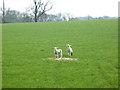
Swaletree House Farm, Kirby Wiske
One of the farms on the Sion Hill Hall estate, and built on a low hill above the flood level.
Image: © Gordon Hatton
Taken: 16 Apr 2007
0.02 miles
2

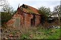
Building at Swaletree House Farm falling into Disrepair
Substantial building within the compound of Swaletree House Farm which appears to have been abandoned
Image: © Chris Heaton
Taken: 14 Apr 2016
0.04 miles
3
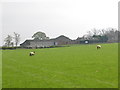
Mint sauce anyone?
Lambs in the field near Swaletree House Farm.
Image: © Gordon Hatton
Taken: 16 Apr 2007
0.16 miles
4
Building at Summerfield House Farm falling into Disrepair
Red brick building within the compound of Summerfield House that appears to have been abandoned
Image: © Chris Heaton
Taken: 14 Apr 2016
0.19 miles