IMAGES TAKEN NEAR TO
Busby Stoop, THIRSK, YO7 4EH
Introduction
This page details the photographs taken nearby to Busby Stoop, YO7 4EH by members of the Geograph project.
The Geograph project started in 2005 with the aim of publishing, organising and preserving representative images for every square kilometre of Great Britain, Ireland and the Isle of Man.

There are currently over 7.5m images from over14,400 individuals and you can help contribute to the project by visiting https://www.geograph.org.uk
Image Map (Loading...)


Getting Data...Please wait
Leaflet Map data © OpenStreetMap
Images are licensed for reuse under creativecommons.org/licenses/by-sa/2.0
Notes
- Clicking on the map will re-center to the selected point.
- The higher the marker number, the further away the image location is from the centre of the postcode.
Image Listing (4 Images Found)
Images are licensed for reuse under creativecommons.org/licenses/by-sa/2.0
Image
Details
Distance
1
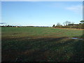
Crop field near Morndyke House
Frosty morning view.
Image: © JThomas
Taken: 16 Dec 2017
0.06 miles
2
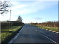
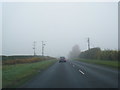
A61 towards the A1(M)
Looking south west, Skipton-on-Swale.
Image: © JThomas
Taken: 16 Dec 2017
0.10 miles
3
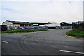
Bowood Yorkshire Lamb
The local abattoir which provides beef and lamb products.
Image: © Bill Boaden
Taken: 23 Aug 2013
0.17 miles