IMAGES TAKEN NEAR TO
Borrowby, THIRSK, YO7 4AW
Introduction
This page details the photographs taken nearby to YO7 4AW by members of the Geograph project.
The Geograph project started in 2005 with the aim of publishing, organising and preserving representative images for every square kilometre of Great Britain, Ireland and the Isle of Man.

There are currently over 7.5m images from over14,400 individuals and you can help contribute to the project by visiting https://www.geograph.org.uk
Image Map
Images are licensed for reuse under creativecommons.org/licenses/by-sa/2.0
Notes
- Clicking on the map will re-center to the selected point.
- The higher the marker number, the further away the image location is from the centre of the postcode.
Image Listing (6 Images Found)
Images are licensed for reuse under creativecommons.org/licenses/by-sa/2.0
Image
Details
Distance
1
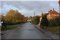
Entering Borrowby from the South
The village rises up a hill, along this single road on the edge of the Vale of Mowbray.
Image: © Chris Heaton
Taken: 15 Nov 2019
0.03 miles
2
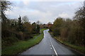
Oaktree Bank
Oaktree Bank descending to cross Broad Beck, between the communities of Knayton and Borrowby.
Image: © Chris Heaton
Taken: 15 Nov 2019
0.09 miles
3
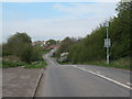
Former A19 at Borrowby
Forty years ago this was a major highway, but it is now a minor road linking Borrowby with Knayton. The A19 dual carriageway is 200m or so to the east.
Image: © Gordon Hatton
Taken: 16 Apr 2007
0.10 miles
4
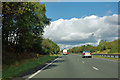
A19 northbound
The small yellow posts on the verge appear to have flashes on them, normally associated with something electrical. There are also a few words, which no doubt explain further.
Image: © Robin Webster
Taken: 7 Oct 2011
0.16 miles
5
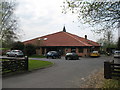
Knayton Primary School
A smart modern building well sited between Borrowby and neighbouring Knayton.
Image: © Gordon Hatton
Taken: 16 Apr 2007
0.24 miles
6
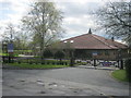
Knayton Church of England School and Borrowby Playgroup and Nursery building
Image: © Peter Robinson
Taken: 15 Apr 2012
0.24 miles