IMAGES TAKEN NEAR TO
Cundall Road, THIRSK, YO7 3RB
Introduction
This page details the photographs taken nearby to Cundall Road, YO7 3RB by members of the Geograph project.
The Geograph project started in 2005 with the aim of publishing, organising and preserving representative images for every square kilometre of Great Britain, Ireland and the Isle of Man.

There are currently over 7.5m images from over14,400 individuals and you can help contribute to the project by visiting https://www.geograph.org.uk
Image Map (Loading...)


Getting Data...Please wait
Leaflet Map data © OpenStreetMap
Images are licensed for reuse under creativecommons.org/licenses/by-sa/2.0
Notes
- Clicking on the map will re-center to the selected point.
- The higher the marker number, the further away the image location is from the centre of the postcode.
Image Listing (3 Images Found)
Images are licensed for reuse under creativecommons.org/licenses/by-sa/2.0
Image
Details
Distance

2
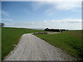
Leckby Villa Farm
Looking down the access lane towards the farm, from the Cundall to Topcliffe Road
Image: © Chris Heaton
Taken: 4 Apr 2007
0.20 miles
3

Field near The Carr
Arable land and planted woodland, suggested by the OS Map as The Carr
Image: © Chris Heaton
Taken: 4 Apr 2007
0.23 miles