IMAGES TAKEN NEAR TO
Dishforth Road, THIRSK, YO7 3QJ
Introduction
This page details the photographs taken nearby to Dishforth Road, YO7 3QJ by members of the Geograph project.
The Geograph project started in 2005 with the aim of publishing, organising and preserving representative images for every square kilometre of Great Britain, Ireland and the Isle of Man.

There are currently over 7.5m images from over14,400 individuals and you can help contribute to the project by visiting https://www.geograph.org.uk
Image Map
Images are licensed for reuse under creativecommons.org/licenses/by-sa/2.0
Notes
- Clicking on the map will re-center to the selected point.
- The higher the marker number, the further away the image location is from the centre of the postcode.
Image Listing (46 Images Found)
Images are licensed for reuse under creativecommons.org/licenses/by-sa/2.0
Image
Details
Distance

4
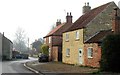
Brick and stone in Asenby
Two old cottages in Asenby, one brick built and the other made from stone. The front of the nearer property had coursed stone, whilst the gable end is rubble built. I'm unsure of the source of this stone, which looks like a creamy sandstone from somewhere further east.
Image: © Gordon Hatton
Taken: 25 Dec 2018
0.13 miles
5
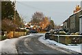
Main Street Asenby
Asenby and Topcliffe are twin villages sharing a village hall and a local newssheet, but they are separated by the River Swale and also by district boundaries with Asenby in Harrogate district and Topcliffe in Hambleton. Topcliffe is busy whereas Asenby is somewhat of a backwater being by-passed by major roads.
Image: © Gordon Hatton
Taken: 9 Jan 2021
0.13 miles
6
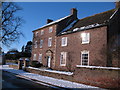
Asenby Hall
Frederick Clarke farmed here in the 1890's
Image: © David Rogers
Taken: 10 Jun 2009
0.13 miles
7
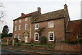
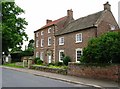
Asenby Hall
The finest house in the main street, Asenby Hall is a three bay, three storey late 18th century house of brick with stone features. Slightly unusual in not having a central doorway, and with a later extension to the right.
Image: © Gordon Hatton
Taken: 8 Jan 2010
0.13 miles
8
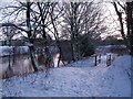
Riverside path, Asenby
The footpath by the Swale on the Asenby side of the river.
Image: © Gordon Hatton
Taken: 18 Dec 2009
0.14 miles
9
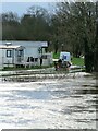
Building up the defences
Men at work laying sandbags along the top of the riverbank in an effort to stop the Swale inundating the caravan park. The bank was raised on this side in the winter of 2019 as the caravan site had been flooded in the past, but even this work was severely tested in January 2021 due to exceptionally high river levels, some 5m above normal. The sandbags were just about enough to prevent a flood into the site.
Image: © Gordon Hatton
Taken: 21 Jan 2021
0.15 miles
