IMAGES TAKEN NEAR TO
Sessay, THIRSK, YO7 3JF
Introduction
This page details the photographs taken nearby to YO7 3JF by members of the Geograph project.
The Geograph project started in 2005 with the aim of publishing, organising and preserving representative images for every square kilometre of Great Britain, Ireland and the Isle of Man.

There are currently over 7.5m images from over14,400 individuals and you can help contribute to the project by visiting https://www.geograph.org.uk
Image Map
Images are licensed for reuse under creativecommons.org/licenses/by-sa/2.0
Notes
- Clicking on the map will re-center to the selected point.
- The higher the marker number, the further away the image location is from the centre of the postcode.
Image Listing (13 Images Found)
Images are licensed for reuse under creativecommons.org/licenses/by-sa/2.0
Image
Details
Distance
1
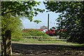
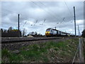
Passing train
Looking towards the East Coast Mainline as a Virgin class 91 hauled train passes.
Image: © DS Pugh
Taken: 5 May 2018
0.03 miles
2
Sessay railway station (site), Yorkshire
Opened in 1841 by the Great North of England Railway, soon to become part of the North Eastern Railway, on the line from York to Darlington. The station was rebuilt in 1942 when the line was quadrupled, but closed to passengers in 1958 and completely in 1964.
View north towards Thirsk and Darlington.
Image: © Nigel Thompson
Taken: 25 Aug 2008
0.05 miles
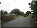
3
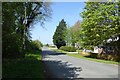
Road to Dalton
Looking along the road to Dalton from the junction with Blind Peace Lane.
Image: © DS Pugh
Taken: 5 May 2018
0.06 miles
4
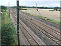
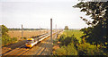
South Bound at Speed
The East Coast Main Line. Trains are travelling at well over 100 mph on this section.
Image: © Martin Dawes
Taken: 8 Apr 2009
0.06 miles
5
Bridge over the railway east of Dalton Moor
Image: © John Slater
Taken: 14 Jul 2019
0.07 miles
6
Site of Sessay station, ECML 1993
View northward from bridge on minor road between Sessay and Dalton, on ex-NER York - Darlington section of the ECML. The line was electrified in 1988, but the Up express tearing past is an HST. The station had been rebuilt during the wartime quadrupling of 1942, as an island behind the camera, but was closed 15/9/58.
Image: © Ben Brooksbank
Taken: 1 Sep 1993
0.07 miles
7

Blind Piece Lane (3)
Quiet country lane heading north towards Dalton Moor
Image: © Chris Heaton
Taken: 20 Oct 2015
0.09 miles
8
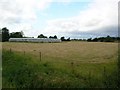
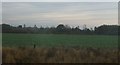
Greenhouses near Dalton
The East Coast Mainline railway runs at the back of this image.
Image: © DS Pugh
Taken: 9 Jul 2006
0.10 miles
9

Site of former Sessay station, ECML 2002
View eastward from the Dalton - Sessay road. Sessay station was on the ex-NER York (to right) - Northallerton (to left) section of the East Coast Main Line and was completely rebuilt during the widening works here in World War Two, completed 5/43. The station was closed to passengers from 15/9/58, to goods from 10/8/64, but it is possible that this house - although rather grand, had been the station house, because the architecture is very similar to that of other stations rebuilt during the earlier widenings along this stretch carried out in the 1930s. [?]
Image: © Ben Brooksbank
Taken: 22 Jun 2002
0.10 miles