IMAGES TAKEN NEAR TO
Dalton Lane, THIRSK, YO7 3HR
Introduction
This page details the photographs taken nearby to Dalton Lane, YO7 3HR by members of the Geograph project.
The Geograph project started in 2005 with the aim of publishing, organising and preserving representative images for every square kilometre of Great Britain, Ireland and the Isle of Man.

There are currently over 7.5m images from over14,400 individuals and you can help contribute to the project by visiting https://www.geograph.org.uk
Image Map (Loading...)


Getting Data...Please wait
Leaflet Map data © OpenStreetMap
Images are licensed for reuse under creativecommons.org/licenses/by-sa/2.0
Notes
- Clicking on the map will re-center to the selected point.
- The higher the marker number, the further away the image location is from the centre of the postcode.
Image Listing (5 Images Found)
Images are licensed for reuse under creativecommons.org/licenses/by-sa/2.0
Image
Details
Distance
1

Cod Beck Mill
Home of Cod Beck Blenders on Dalton Lane.
Diverse manufacturer to the pharmaceutical, agricultural, horticultural and food industries.
Image: © Chris Heaton
Taken: 30 May 2021
0.05 miles
2
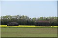
World War 2 remains
Two surviving buildings from the former RAF Dalton airfield which flew mainly Wellington and Halifax bombers from November 1941.
Image: © Gordon Hatton
Taken: 14 Apr 2020
0.13 miles


5
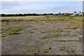
Disused Dalton Airfield
This is the northern section of the disused Dalton Airfield, which saw action with Bomber Command during the Second World War.
Nowadays part of the old site is used for agriculture and part as an industrial estate.
Image: © Chris Heaton
Taken: 20 Oct 2015
0.23 miles