IMAGES TAKEN NEAR TO
Baldersby Park, THIRSK, YO7 3BZ
Introduction
This page details the photographs taken nearby to Baldersby Park, YO7 3BZ by members of the Geograph project.
The Geograph project started in 2005 with the aim of publishing, organising and preserving representative images for every square kilometre of Great Britain, Ireland and the Isle of Man.

There are currently over 7.5m images from over14,400 individuals and you can help contribute to the project by visiting https://www.geograph.org.uk
Image Map
Images are licensed for reuse under creativecommons.org/licenses/by-sa/2.0
Notes
- Clicking on the map will re-center to the selected point.
- The higher the marker number, the further away the image location is from the centre of the postcode.
Image Listing (14 Images Found)
Images are licensed for reuse under creativecommons.org/licenses/by-sa/2.0
Image
Details
Distance
1
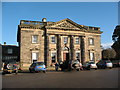
Queen Mary's School
Queen Mary's School aka Baldersby Park, was originally built in the Palladian style in 1721 by a young Scottish architect, Colen Campbell. Amongst its previous owners was George Hudson, the 'Railway King' and one time Lord Mayor of York. The building became a convalescent home for injured soldiers in WW1, was used again by the military in WW2 and became Queen Mary's School for girls in 1985.
Image: © Gordon Hatton
Taken: 7 Mar 2007
0.01 miles
2
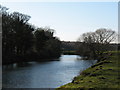
The Swale at Baldersby Park
Looking upstream along the Swale from the left bank of the river opposite Baldersby Park - now a private school for girls.
Image: © Gordon Hatton
Taken: 6 Feb 2007
0.08 miles
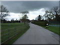
3
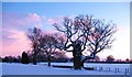
Winter afternoon, Baldersby Park
A wintry scene in Baldersby Park, with a venerable old oak tree in the foreground.
Image: © Gordon Hatton
Taken: 7 Jan 2010
0.10 miles
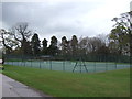
4
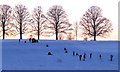
School can be fun!
Pupils from Queen Mary's School enjoying a games lesson with a difference on a January afternoon.
Image: © Gordon Hatton
Taken: 7 Jan 2010
0.10 miles
5
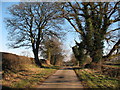
Catton Lane Topcliffe
A quiet back lane lined with mature ash and oak trees.
Image: © Gordon Hatton
Taken: 6 Feb 2007
0.11 miles
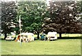
8
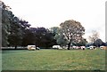
Baldersby Park
A weekend caravan rally at Baldersby Park.
Image: © Gerald England
Taken: 16 Jun 1985
0.13 miles
9
Baldersby Park
A weekend caravan rally at Baldersby Park.
Image: © Gerald England
Taken: 16 Jun 1985
0.14 miles
10
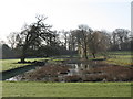
Ornamental Lake, Baldersby Park
This ornamental lake, or 'canal' still exists in Baldersby Park [though not shown on OS 1:50000 map] and lines up between the house and an obelisk, which can just be seen in the background. [and which is in squareSE3875]
Image: © Gordon Hatton
Taken: 7 Mar 2007
0.17 miles