IMAGES TAKEN NEAR TO
North Kilvington, THIRSK, YO7 2NR
Introduction
This page details the photographs taken nearby to YO7 2NR by members of the Geograph project.
The Geograph project started in 2005 with the aim of publishing, organising and preserving representative images for every square kilometre of Great Britain, Ireland and the Isle of Man.

There are currently over 7.5m images from over14,400 individuals and you can help contribute to the project by visiting https://www.geograph.org.uk
Image Map (Loading...)


Getting Data...Please wait
Leaflet Map data © OpenStreetMap
Images are licensed for reuse under creativecommons.org/licenses/by-sa/2.0
Notes
- Clicking on the map will re-center to the selected point.
- The higher the marker number, the further away the image location is from the centre of the postcode.
Image Listing (2 Images Found)
Images are licensed for reuse under creativecommons.org/licenses/by-sa/2.0
Image
Details
Distance
1
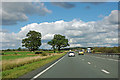
Trees by the A19
Just north of the settlement of North Kilvington.
Image: © Robin Webster
Taken: 7 Oct 2011
0.11 miles
2
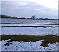
Parallel lines
A field by the A19 at North Kilvington where old ridge and furrow lines are enhanced by the snow cover.
Image: © Gordon Hatton
Taken: 8 Feb 2012
0.14 miles