IMAGES TAKEN NEAR TO
Over Silton, THIRSK, YO7 2LH
Introduction
This page details the photographs taken nearby to YO7 2LH by members of the Geograph project.
The Geograph project started in 2005 with the aim of publishing, organising and preserving representative images for every square kilometre of Great Britain, Ireland and the Isle of Man.

There are currently over 7.5m images from over14,400 individuals and you can help contribute to the project by visiting https://www.geograph.org.uk
Image Map
Images are licensed for reuse under creativecommons.org/licenses/by-sa/2.0
Notes
- Clicking on the map will re-center to the selected point.
- The higher the marker number, the further away the image location is from the centre of the postcode.
Image Listing (48 Images Found)
Images are licensed for reuse under creativecommons.org/licenses/by-sa/2.0
Image
Details
Distance
1
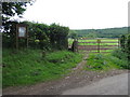
Notice Board & Footpath
There is no made up road to St Mary's at Over Silton but two footpaths lead off Kirkings Lane across the fields to the church.
Image: © David Rogers
Taken: 23 Jun 2008
0.05 miles
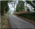
2
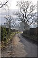
Birghill Lane
Looking down the lane from Kirk Ings lane.
Image: © Nick W
Taken: 29 Jan 2011
0.08 miles
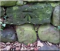
3
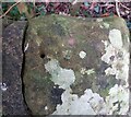
Over Silton, Kirk Ings Lane
The rivet benchmark is cut into an old stone gatepost which is now sandwiched between 2 stone walls on the south side of the lane. The cutmark is damaged.
Image: © Mel Towler
Taken: 5 Jan 2023
0.08 miles
4
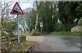
Over Silton, Kirk Ings Lane
There is a rivet benchmark cut into an old stone gatepost which is now sandwiched between 2 stone walls and to the left of the steep slope road sign. The cutmark is damaged. The rivet has gone although the hole remains.
Image: © Mel Towler
Taken: 5 Jan 2023
0.08 miles
5
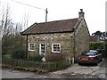
Old school, Over Silton
This modest little building has an inscribed stone on the wall which reads 'This School was built 1844'.
Image: © Gordon Hatton
Taken: 5 Mar 2008
0.09 miles
6
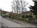
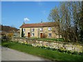
Village street - Over Silton
Over Silton is a very small village with only one short stretch which could be described as a 'village street'. Lined with brown sandstone cottages.
Image: © Gordon Hatton
Taken: 5 Mar 2008
0.09 miles
7
Over Silton, Cart Riggin
There is a benchmark cut into the roadside wall on the south side of Cart Riggin. This cutmark does not appear on the OS benchmark database but it is marked on the 1912 OS map of the area.
Image: © Mel Towler
Taken: 5 Jan 2023
0.09 miles
8
Over Silton, Cart Riggin
The benchmark is cut into the roadside wall on the south side of Cart Riggin. This cutmark does not appear on the OS benchmark database but is marked on the 1912 OS map of the area.
Image: © Mel Towler
Taken: 5 Jan 2023
0.09 miles
10
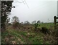
Nether Silton, Bridleway
There is a benchmark cut into a right cornerstone of the remains of a ruined building on the west side of the path. Very little remains of the building.
Image: © Mel Towler
Taken: 5 Jan 2023
0.13 miles